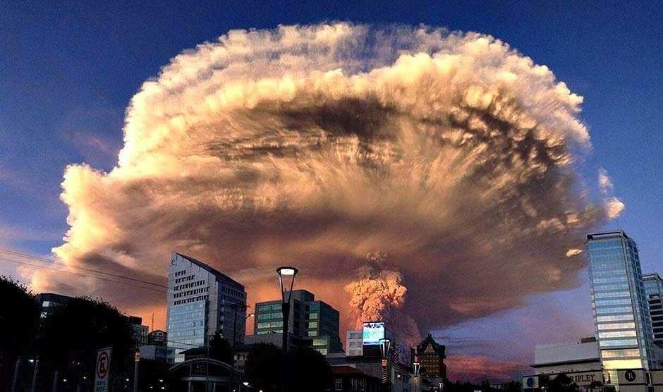
Photo of the 2015 explosion of Calbuco Volcano in Chile, by Keraunos ob, posted on the Earth of Fire blog by Bernard Duyck.
By Jo Nova
A year ago I wrote about the odd link between the Hunga Tonga volcanic dust and floods in Australia, but perhaps volcanic dust also played a role in the savage rain bombs of 1893 that caused the infamous floods of Brisbane?
After Hunga Tonga erupted last year, about a week later unusually heavy rain started falling over Australia — even washing out the Indian Pacific Railway line connecting East and West Australia. A month later and the dust had gone around the world and returned to give us glorious sunsets followed by more rain bombs.
So it may be just a coincidence, but the second heaviest Australian rain bomb was on Feb 3, 1893. And three weeks earlier on January 7th the Calbuco Volcano in Chile had its largest eruption in the last 130 years?
In 1893 an astonishing, flabbergasting day occurred, where 907mm of rain dropped from the sky on Crohamhurst in Queensland (that’s nearly 36 inches!). It came in an astonishing week, where the heavens dumped 2 meters of rain (6.6 ft) in just four days subsequently causing some of the worst flooding Brisbane has ever seen as the waters collected and flowed downstream.
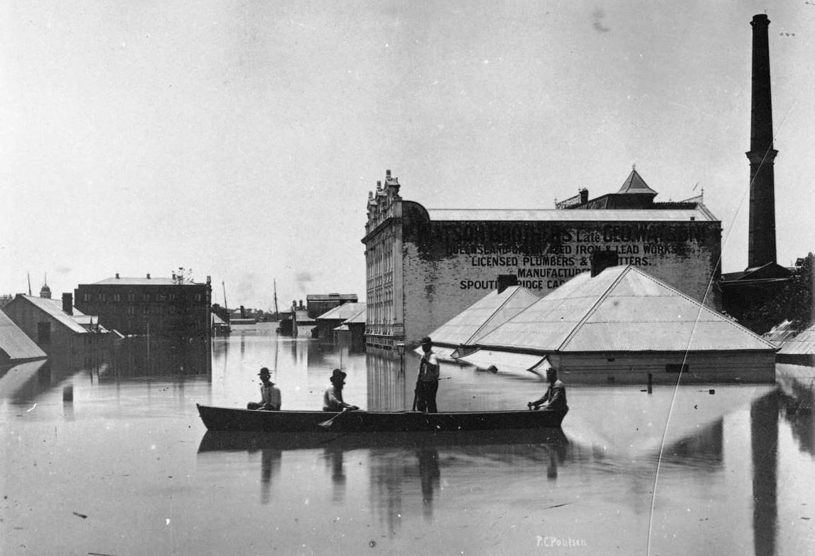
Brisbane floods 1893, Poul C Poulsen. | ANMM Collection |
From February 1 to 4 a total of 1,964 mm of rain fell. There were cyclones in the area, but these were two weeks earlier, so unlikely to be the cause of such a downfall. Was it seeded by volcanic dust? Maybe.
h/t El Gordo for suggesting Calbuco
Volcanoes in Chile can certainly send dust over Australia
In 2011, the ash from a volcano-next-door in Chile, Puyehue-Cordon Caulle, shut down flights in Sydney a week after going off. The ash then travelled right around the world and came back to shut flights down again 10 days later — this time at a lower altitude.
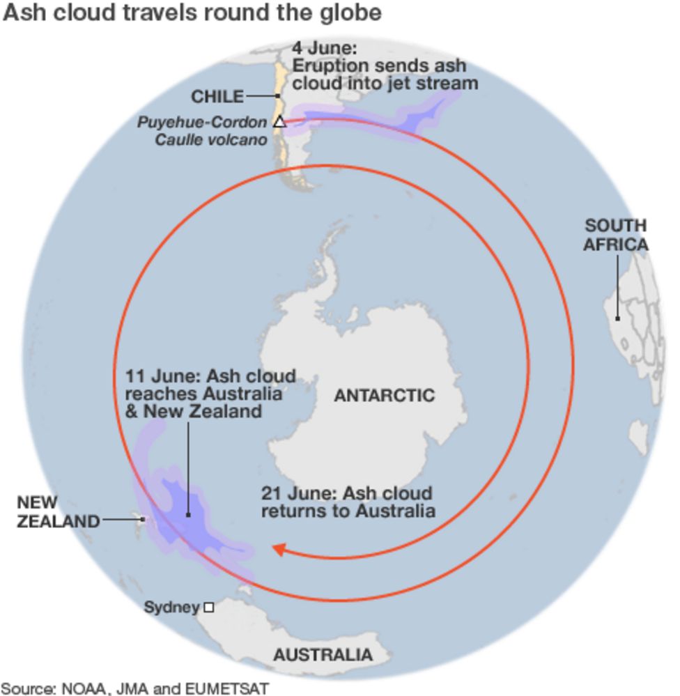
In 2011, ash travelled around the world twice — taking 7 days and then another ten to do the second lap. BBC
So this track (through Sydney) would have been too far south to reach Brisbane, but other times volcanic dust travels north. (The path in the map above seems figurative, not literal…).
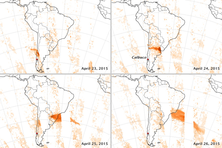
The two volcanoes we are discussing in Chile lie at 41 degrees south compared to Crohamhurst in Queensland, Australia, which is only 27 degrees south and much closer to the equator. But in a smaller 2015 explosion, the dust from Calbuco was tracked moving north from 41°S up to about 30°S within just a few days — putting it a lot closer to the right latitude for Southern Queensland. With no satellites in 1893, we don’t know where the dust went, but we know there was probably a lot of it, and it went somewhere…
In 1893 the Calbuco explosion was a large one:
According to the Department of Geological and Mining Engineering at Michigan Tech:
The first historically documented eruption began on 7 January 1893 and lasted until mid-January 1894. The initial phase of this eruption was violently explosive and led to the generation of destructive lahars. During the later stages of the activity, the volcano may have extruded lava although this is not certain.
Minor eruptions occurred in 1895, 1906, on 22 April 1907, in March 1909, and in 1911-1912; none of these events produced lava flows or lahars.
In 2015 a smaller eruption at Calbuco in 2015 sent dust to the North:
On 23 April at around 2330, a third period of activity resulted in ash plumes rising 2 km and drifting NE and E. On 24 April the ash plume continued to rise 2 km and explosions were detected. News articles noted that international travel was disrupted; flights in and out of several major cities were delayed or canceled. Thermal anomalies, based on MODIS satellite data, were also observed during 23-24 April.
According to one news report, ash from the eruption reached southern Brazil on 25 April, prompting some airlines to cancel flights in and out of Santiago, Buenos Aires, and Montevideo. Some houses in areas near the volcano had collapsed from the weight of the ash. Sporadic explosions caused continued ash plumes 25 April, but to a lower height of 400 m. Seismicity declined during 26-27 April; ash rose 1.5 km, and drifted NE and SE.
By 28 April, a satellite-based estimate of sulfur dioxide emissions was 0.3-0.4 Tg (Tg is one million metric tons), detected as high as 21 km altitude.
NASA tracking shows the plume from Calbuco can travel north quickly.
Tracking the Sulfur Dioxide from Calbuco, NASA
The CSIRO discusses the extreme weather events of 1893 but doesn’t mention any volcanoes
According to the CSIRO there were a series of tropical cyclones (TC) in Jan and Feb 1893, but none of the dates fit the monster downpour on Feb 1-4. The cyclone on Jan 22 would have soaked the ground, but not caused big rain nearly two weeks later.
A TC during 21–22 January 1893 passed just east of Brisbane where gusts reached 57 knots (28 m/s) with the MSLP down to 985.1 hPa at 1700UTC 22 January 1893 (Fig. 2). There was a large storm surge in Moreton Bay to 0.58 m (Gourlay 1981) with widespread sea damage at Sandgate, Cleveland and Southport. Heavy rain fell across SEQ with the heaviest 24-h total of 179.8 mm at Mount Tamborine. There were two deaths in northern NSW with heavy gales at Lismore, Casino, Grafton and Sydney.
For Brisbane, the monster rain collected into a major flood. Indeed, many floods in 1893 — on the 5th, 12th and 19th February, and again on the 12th of June. The flooding on the 5th of Feb was the second highest after the 1841 floods.
3.3 First 1893 flood – possibly the worst in Australian history
The largest recorded flood in Brisbane City was 8.35 m on 5 February 1893 (Brunt 1958; Newman 1958) and the unprecedented conditions resulted in at least 30 fatalities. Early on 3 February a 15.2-m high wall of water was observed to roar down a Brisbane River gorge. The water tumbled down the Stanley River to its junction with the Brisbane River. Nearby was Caboonbah, the residence of grazier Mr. H.P. Somerset. Caboonbah (Fig. 3a ) is on high ground, with a view of the Brisbane River below its junction with the Stanley River. Crohamhurst (on the Stanley River) recorded 907 mm of rain in the 24 h to 9 am 2 February 1893 and this was an Australian record for 24-h rainfall up until 1979. The location of Crohamhurst and the 96-h rainfall is shown in Fig. 3b .
For whatever it’s worth there were no mass rain events in 1893 in Melbourne or Sydney. If La Nina was the main culprit (or widespread volcanic dust) we would have expected to see major rain there too.
We can’t say much about a path of a dust cloud 130 years ago — only that it might have been in the right place at the right time.
Related:
- The devastating floods of Brisbane in 1893
- There were Bigger Floods and Rain-bombs in the 1800’s
- Did volcanic dust from Hunga Tonga cause flooding in Australia?
- Calbuco Volcano lies at 41.33°S 72.61°W


Another extraordinary, well documented, venture into the explanation of the world we live in.
Why is this type of scientific assessment beyond the scope of our nations once great scientific organisation?
Real Science Rules!
430
Because it’s now a political organisation whose job is to spread the political message of supposed catastrophic anthropogenic global warming.
It’s not needed. They have the ABC to spread Government political propaganda, they don’t need the CSIRO as well.
Here’s an idea. How about CSIRO get out of the propaganda business and return to science or just be disbanded and the savings used to pay off national debt?
440
The CSIRO’s Climate Change department was purpose built. In December 1986 the Hawke government put their own brand of social scientists in charge of the real scientists, with Neville Wran as chairman.
I would expect that the rest of the CSIRO might be still delivering a return on investment.
170
I would expect that in addition to the dust these cataclysmic events might generate turbulence that lasts for a considerable time.
I recall a farm burnoff on a clear day which created a cloud which turned into a small storm with 14 points of rain about 20 km down wind.
The “Sir Ivan” bushfire a few years back created storms with lightning strikes lighting a number of new fires about 30 km down wind.
I don’t recall the details, but remember people associating rain across the Australian continent following atom bom tests on Monte Bello Island.
140
No no no, as every obedient climate scientist [sic] knows, ’twas EWM – Evil White Men – what done it. The volcano was simply foreshadowing the MMC – Man-Made Crisis – soon to appear, in 1988. Chilean volcanoes can be ‘aspirational’ too. Let’s not mention NZ’s Taupo caldera which, ~2,000 years ago, erupted enough goop to blot out the sun in Rome and China and Greta-knows where else…
Over the past few days, while your Snowy Mountains were dusted with (cough!) snow, the same storm system spawned mini-tornadoes amidst the rain squalls drenching parts of NZ. Educated fools here have been quick to blame it on YKW – You Know What – concocting all sorts of theories to blame weather on the peasants. A certain Dr [sic] Kevin Trenberth was first out of the blocks, blaming ‘carbon’ for cooking sea temperatures around our islands: note, SST are very average for this time time of year so again, the ‘Doctor’ is living in the land of make-believe.
Waiting on the the next volcano to blow…
290
My wife and I visited Taupo in 2019. A most beautiful place. It sure is a big hole now filled with water. Obviously no one seems concerned that it might blow again.
As for the CSIRO they can be lumped together with the BoM and the Chief Scientist more concerned with their taxpayer largesse than truth. They are truly defrauding Australians.
190
Drove past Taupo in 1970.
50
Did you notice the little island, Motu Taiko, off the eastern side, opposite Earthquake Gully? Supposedly that’s the ‘plug’, the bung, keeping the fires of hell from re-emerging.
The 3 present-day ‘live’ volcanoes to the south, including Mt Ruapehu (9,000ft), are mere pimples compared to the GIANT collapsed caldera of Taupo-a-nui (nui = big). The hot-spot underneath is gradually shifting south (as the land above drifts north) so the next ‘big one’ could be offshore in the Taranaki Bight… good luck to those climate fakirs who’ve bought seaside mansions in NSW…
80
So long ago Greg. I may have stayed in a nearby youth hostel but don’t remember much except that Taupo was flat.
Ruapehu was impressive.
10
So where will the rain bomb manifest from the Russia eruption I wonder.
https://www.news.com.au/technology/science/flight-chaos-as-massive-volcano-goes-off-in-russia/news-story/990aaae247923c158469af81dcf62b8c
70
The CSIRO, like the ABC, is an irredeemable basket case, not just because it has been politicised, but also because it no longer serves the purpose for which it was created AND the quality and value of its outputs are quite pathetic, of little benefit to Australians. The waste is eye watering.
If all the ‘dead end’ research was shut down, all the duplication of programmes and projects halted, REAL, MEASURABLE outcomes aligned with all Australians’ needs enforced and all the dead wood pruned away, its continued existence might be justified. But like a reformed ABC just isn’t going to happen, I believe the CSIRO will lumber along, sucking up taxpayers’ money and churning out fake, politically biased and flawed science. Because THAT’S it’s real charter nowadays.
The Long Slow March continues.
190
In a moment of stupidity I decided to subscribe to the CSIRO twitter feed. Mistakenly thinking I might get some good science info. OMG!! I think they may have recruited the editors for the twitter feed from ABC’s Q & A program. It’s the most wokest, climate change alarmism type info that can be written. Somedays it’s actually good for a laugh. Mostly because the “cute” tweets are about wombats. Yes wombats, which is what most of their personnel would appear to be impersonating. The whole organisation is just another government/public service department, but in this case constantly on the prowl for research grants also. The fact that this organisation is the main scientific advisory body for federal government is a real worry.
70
Over 45 years ago I knew one (Industrial) chemist who was moon-lighting as a cleaner at a CSIRO laboratory. He came back shaking his head and wondering about the work these. He thought that the pay would be better but it must be very boring as very little was happening.
A patronising PhD explained what he was doing with his “experiment” in the fume hood, not realising that Ian knew what was going on, or NOT.
He kept an eye on “the experiment” over the week without any change evident, just a flask (with condensor etc. to look impressive to managerial types passing by) being stirred day after day.
I had dealings with some of their researchers twice, neither fruitful. The “great breakthrough” in resin production lasted less than 30 seconds in our laboratory. They went back to base but we heard nothing more.
40
constantly on the prowl for research grants
The issue in a nutshell
00
Here are some other eruptions of Calbuco. I wonder if they also corresponded with weather events in Australia?
Note that the 1893 event had a volcanic explosivity index (VEI) of 4 (the higher the number the more eruptive the event). The only other one with a VEI 4 in this list is the 2015 eruption (mentioned by Jo).
2015 Apr 22 – 2015 May 26 Confirmed Eruption Max VEI: 4
1972 Aug 26 – 1972 Aug 26 Confirmed Eruption Max VEI: 2
1961 Feb 1 – 1961 Mar 26 (in or after) Confirmed Eruption Max VEI: 3
1945 Confirmed Eruption
1932 Confirmed Eruption
1929 Jan 6 – 1929 Jan 6 Confirmed Eruption Max VEI: 3
1917 Apr – 1917 May Confirmed Eruption Max VEI: 3
1911 – 1912 Confirmed Eruption Max VEI: 2
1909 Mar Confirmed Eruption Max VEI: 2
1907 Apr 22 Confirmed Eruption Max VEI: 2
1906 Confirmed Eruption Max VEI: 2
1894 Nov 16 – 1895 (?) Confirmed Eruption Max VEI: 2
1893 Jan 7 – 1894 Jan 16 (in or after) Confirmed Eruption Max VEI: 4
Source: https://volcano.si.edu/volcano.cfm?vn=358020
80
Here in NZ the Manawatu River ceased to be a braided river in my location and became a single stream, where it remains today . The record flooding in NZ around this time is well documented.
The flooding occurred throughout the country , and continued through 1895.
https://hwe.niwa.co.nz/event/August_1893_Waikato_Flooding
120
The wisdom of Chris Brandolino again?
“Altogether such a misfortune had not happened since the 1875 flood.”
18 years prior… Hmm, blame it on the moon?
80
Some scientists say man made CO2 caused rapid tipping point Global Warming causes volcanic eruptions. The planet was perfect until the invention of CO2.
270
Yeah all bases covered.
00
Fascinating article, Jo. For years I have tried to get people to check the big role of volcanos on our weather. Instead of ‘parroting” the mantra of climate change and horrible CO2, this article alone should cause people to look at real science occasionally. Back when Mt Pinatubo violently erupted the sky was pink in the afternoons for months. a strong indicator of the vast chemical output from a major eruption. The vast climatic effect of Mt Tambora and Mt Krakatoa are well known but there are volcanos erupting all the time which should be taken into account on climate.
160
Has the Author forgotten the 15th January eruption in Tonga?
It sent way more sea water into nearly space than the Chile eruption. Over 10% of the water in the stratosphere was now sea water!
That water has been and will continue to circulate for many years as it is way higher than the dust clouds and has way more influence upon the weather!
It also contains Salt crystals, a highly reflective substance!
It was much more recent that the Chile eruption!
Where is the evidence that Chilean dust was in that rain?
100
Not to mention, salt in the troposphere is a particularly effective aerosol particle instigation cloud formation. Ice crystals in the stratosphere and mesosphere will be very interesting study for meteorologists for decades to come…if they ever grow an interest.
90
so we’ll, nay, THEY! will not now need to spread that other whitestuff into the atmosphere, ( talked about recently – but I’ve purposefully forgotten the detail – waste of grey matter space ), to cool the planet. Wait around long enough and Mother Nature on her ( his – ha ha ha! ) rounds, comes back with the Trolley !
00
For those that may be interested I subscribe to the YouTube channel GeologyHub which gives almost daily updates of various volcano activity or other geological oddities. Each video is about 4 to 5 mins.
https://youtube.com/@GeologyHub
100
The homeopathic school of climate science would assert that a butterfly beating its wings would have more impact on global weather than a volcano erupting.
150
“The homeopathic school of climate science” Nice but I think homeopathic is more scientific.
Cause and effect can be proven with homeopathic.
50
I used to work in a “Stop Smoking” clinic developed along the lines of clinical ecology a la Dr Richard Mackarness. I saw first hand the impact of 1in10,000 dilution of nicotine on the signs and symptoms of craving. Very impressive.
30
Butterflys are cute – they get a pass. Instead think some middle aged white male farmer farting in the middle of the outback.
10
Just one point. The ash drops out fairly quickly, as it did with Hunga Tonga last year. What remains are aerosol droplets that are much lighter. These droplets have spread around the tropics and well into the southern temperate zone, in particular Australasia. As far as I can discover the volcanic material has only reached 30 degrees north. Having watched these things closely from N.Z. since Mt Pinatubo in 1991, I find that Hunga Tonga has been very different. The first sign of the aerosol cloud was on April 9th,2022. Almost without exception we have had volcanic twilights at dawn & dusk every day since! This didn’t happen before, even with the great Pinatubo Twilights that lasted for four years. Pinatubo affected our climate in a different way. The eruption was in June 1991. The following summer was very brief. 1992 was very cold, with a high number of T-Max days under 10C. It was also cold because it was dull. Invercargill set a new national low for sunshine hours, while my hometown set a new North Island record for the same thing. Rainfall however was not significant. Pinatubo seemed to bring out the worst in the El Nino event underway at the time. Hunga Tonga seems to have exacerbated the worst features of the weak La Nina that was in place. Las Ninas are renowned for bringing rain to the northeast of Australia, and the N.E. of N.Z. This is exactly what happened over the past 15 months, but with steroids!
90
So where will the rain bomb manifest from the Russia eruption I wonder.
https://www.news.com.au/technology/science/flight-chaos-as-massive-volcano-goes-off-in-russia/news-story/990aaae247923c158469af81dcf62b8c
40
Some people are hoping for the Central Valley in CA?
40
Thanks again Jo and El Gordo for this information and we know that ancient volcanoes have caused big problems over a very long time.
The Toba super volcanic explosion on Sumatra 74000 years ago was perhaps the largest explosion in the last 2.5 million years.
Some scientists thought this reduced the Human population to only 10,000 people but other scientists now dispute that low number.
But the Toba explosion was 100 + times the Mt St Helens explosion, so it would have caused great climatic changes for a very long time.
But we do know that by 1 AD the global Human population was about 100 to 150 million and to increase to those numbers in just 70,000 years is very hard to believe.
Who knows and was there also a Human DNA bottleneck because of the Toba eruption?
https://en.wikipedia.org/wiki/Toba_catastrophe_theory
70
Be interesting to know if these earlier Brisbane River floods were associated with volcanic eruptions:
“Major Edmund Lockyer mentioned evidence of a flood in the area of today’s Mount Crosby pumping station. Based on grass and other debris high on tree branches, his estimate was a flood of some one hundred feet above the normal river level. If we take the official record of the flood level on 4 February 1893 at the pumping station, 94 feet 10.5 inches, it has been suggested that between John Oxley’s visit in September, 1824 and Lockyer’s visit in September, 1825, the river experienced a flood as great as that subsequently experienced in February 1893.”
30
Recordings of such high rainfall figures are most interesting.
However, I have searched without success, an event which occurred on the Gold Coast around the early 1990’s for which I cannot find any official recording. Should I manage to find some photos I took I may be able to be more explicit.
My rain gauge was located about 10km north of Coolangatta airport (Palm Beach) in an open area and was not affected by houses / trees, etc. The event started before around 5am and by 8am the gauge was overflowing at 150mm. By the following day I had emptied the gauge around 5-6 times from memory so the event would perhaps have produced close to 10000 mm.
The entire Gold Coast area was affected.
90
🙂
10
And I’m sure that you meant 10,000.
01
The BIG question…is there a link between major eruptions and earthquakes and low sunspot activity?
50
I am not sure how much of the rain was exacerbated by the eruption but David Burton aka (Inigo Jones) was advising that last year was going to flood in 2022, years before it happened and was warning people all through 2021 to prepare and get out of flood plains.
He also mentions the Aborigines talking about an even bigger flood prior to the late 1800’s flood and that this same planetary cycle is coming around again and will peak in 2025 with the lead up years being cold and very wet.
He is basically saying that rebuilding those flood damaged houses will just result in them being destroyed again as more is coming and it is going to get worse.
better buy a bigger boat
100
La Nina conditions prevailed through the early 1890s for almost 4 years. Actually a longer event than the early 2020s.
https://bmcnoldy.rsmas.miami.edu/tropics/oni/ONI_1870-2023.png
Similar persistence of La Ninas in the early 1970s and late noughties were associated with notable flooding in Brisbane.
If you look at the long dips in the linked chart you will find associated flooding on the east coast of Australia.
I do not think the La Ninas cause the volcanos.
And Siberia was anomalously cold in January; nothing to do with the current Shiveluch eruption.
60
“I do not think the La Ninas cause the volcanos.” me either 🙂
60
The saga of the 1893 Briz Vegas floods (plural) and the Queensland Navy gunboat, “Paluma”.
https://www.navy.gov.au/hmas-paluma-i
40
The BOM must get awfully frustrated by historic flood data and related evidence. Its awfully hard to adjust and manipulate in support “the message”
90
So we have a possibility of dust in the upper Atmosphere. Now where did the moisture come from when 30 deg of latitude is the home of the dry air stripped of moisture as it rises over the tropics?
60
Broadie, I have no trouble with air moving from 41 to 27 degrees S. Occasionally we see blasts of particles from the Sun which charge up the ionosphere. Normal patterns cease and the polar jet-stream swings in a meridonal pattern, sometimes almost looping back on itself and also bouncing up and down like a Chinese dragon. If volcanic ejecta get into the jet stream it might cause radical changes in distant places. The injection of H2O vapour, CO2, SO2, dust etc would temporarily over-ride the normal pattern of planetary air cells.
00
I’ll sure be glad when we finally get meaningful climate policy.
We will no longer have to suffer the warmest ever, or the coldest, driest, wettest evers ever again.
It is non-believers that stand in the way.
60
The long range forecast for this year has been bobbing around with all sorts of predictions. A few months ago it was a predicted “dry” start to the year, so sort of El Nino for Australia. Now, I think it’s been revised and yesterday I saw a 2023 long range forecast for 50% chance of El Nino in the 2nd half of the year. Which also means 50% non chance of that happening as well. So, almost useless as an accurate guide. But never fear, Guardian Australia has sexed that up a tad. They proclaim ” Climate models warn of possible super El Nino before end of year”. How’s that for hyperbole?
70
A strong La Nina seems the likely cause of the Brisbane floods.
https://ensoreview.com/enso/1892-1893-la-nina/
30
A negative Southern Annular Mode might explain the lack of precipitation in Sydney and Melbourne.
10
KK
Oops on the 10,000 when it obviously is 1000 mm. Thanks for correcting my error.
40
The information about the Tongan Volcanic eruption is not quite correct – This volcano erupted under water, from 10 metres down to 190 metres and has been described as an explosive eruption, which occurred when the super hot magma turned the surrounding sea into steam and water vapour, in addition to ash, and various other aerosols. The eruption ejected material 57 kilometres into and above the atmosphere, producing from 5% to 20% increase in Water Vapour in the atmosphere, while also increasing the nuclei needed to create the heavy rain and flooding that followed. There is ample evidence available on the internet about the amount of material, water vapour, and even the devastation caused by an underwater pyroclastic flow which erased all life for up to a 100 kilometres underwater on the sea floor. The Tongan volcano erupted on January 15 2022 and the heavy rains and flooding began in Australia along similar parallels some four or five days later, then gradually drifted south. The effects of the increase in Water Vapour in the atmosphere is believed to be felt for, from 4 to 8 years, depending on the authority. Google Tongan Volcano for further information, there are plenty of thought evoking still and time laps photos, and much information to discover.
60
In 1815 Tambora blew,
And so much volcanic ash spew,
That 1816 was a bummer,
A year without summer,
So dull that many crops never grew.
40
The link below shows a 1 day animation of current dust data from South America.
https://www.star.nesdis.noaa.gov/GOES/sector_band.php?sat=G16§or=ssa&band=Dust&length=240&dim=0
dust+coriolis+pressure+moisture+gravity+time+thought=beautiful complexity 🙂
30
Great article about the great influences upon weather which also includes electric storms which release what would in human terms be infinite supplies of electricity of such magnitude you’d have to wonder how much of that energy completely rewrote what nature was going to do next in certain places on planet Earth and all in just a matter of moments. And yet some idiots still insist they can forecast stuff days, weeks, months, years, decades ahead …
Nature meanwhile tells us that we know so very little but keeps pushing little pockets of information our way – like that black stuff we called oil – with helpful suggestions for experts and entrepreneurs alike to get to grips with – e.g. electric storms are very powerful and fossil fuels can keep you dry and warm, run industrial complexes and have decent jobs and standards of living.
And then along came the Lying Two Faced Mann and nobody with responsibility bothered to stop him and his ilk in their tracks. And so the lack of commitment to the responsibility world leaders have continues to mess with our lives with too few prepared to fight back against poor decision making and mass corruption. But the day the goodies really do fight back and recover sensibility will come and the terrible lies and misinformation we have to tolerate daily on our so called trusted media will stop.
Eventually the outcome will make a great warning type fairy tale style story for future generations to stop stupidity before it does any damage.
As Sun Tzu wrote “If you know the enemy and know yourself, you need not fear the result of a hundred battles. If you know yourself but not the enemy, for every victory gained you will also suffer a defeat. If you know neither the enemy nor yourself, you will succumb in every battle.”
40
A “must read” 🙂
10
Obviously, Climate change is causing volcanic eruptions! Stop misreading the data.
10
Can we measure rain falling on the ocean?
Do our satellites have the ability and the position?
for if the volcanic ejecta is causing heavy rain on lands,should it also rain heavily under the ejecta’s path?
00