UPDATE: Data for Middle Percy Island has disappeared from the BOM site, but Jennifer Marohasy kept a copy. (I’m sure the BOM will be grateful!) The Courier Mail has an article quoting Jennifer.
The facts on Cyclone Marcia: the top sustained wind speed was 156 km and the strongest gust 208 km/hr. These were recorded on Middle Percy Island in the direct path before it hit land and apparently rapidly slowed. The minimum pressure recorded after landfall was 975Hpa. BOM and the media reported a “Cat-5” cyclone with winds of 295 km/hr. To qualify as a Cat 5, windspeeds need be over 280km/hr. The UN GDACS alerts page estimated the cyclone as a Cat 3.
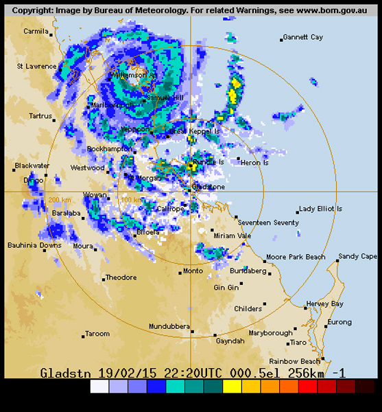
The damage toll so far is no deaths (the most important thing), but 1,500 houses were damaged and 100 families left homeless. It was a compact storm, meaning windspeeds drop away quickly with every kilometer from the eye, so the maps and locations of the storm and the instruments matter. See the maps below — the eye did pass over some met-sites, but made landfall on an unpopulated beach with no wind instruments. It slowed quickly thereafter. The 295 km/hr wind speed was repeated on media all over the world, but how was it measured? Not with any anemometer apparently — it was modeled. If the BOM is describing a Cat 2 or 3 as a “Cat 5”, that’s a pretty serious allegation. Is the weather bureau “homogenising” wind speeds between stations?
What will happen when Australians living in cyclone areas have to prepare for real Cat 5s? How much respect will Australians have for the BOM (and the ABC) if they find out that supposedly dispassionate and impartial scientists have been hyping weather events to score political points? Will the BOM issue any clarifications and corrections?
What does a Cat 5 mean anymore?
The headlines are still calling Marcia a “Cat 5″ cyclone three days later. But today there are many questions about that, and very different debates have broken out on the old media and the new. On the mainstream media, Premier Annastacia Palaszczuk is already defending the BOM after the Marcia “surprise”. But she is talking about the sudden escalation of a Cat 1 or 2 up to a 5, and whether the BOM gave residents enough warning. On the Internet people are asking why it was called a Cat 5. As Jennifer Marohasy points out, the top speeds recorded showed the cyclone was a Category 3. “Middle Percy” was under the path, and out to sea.
There is a weather station on Middle Percy, and it recorded a top wind speed of 156 km/h, the strongest gust was 208 km/h, and the lowest central pressure was 972 hPa. This raw observational data is available at the Bureau’s website and indicates a category 3 cyclone.
As commenters unmentionable and Ken recorded here, none of the observed wind-speeds came remotely close to being Cat 5. By strange coincidence, two guest authors here, Ken Stewart and TonyfromOz, live north of Rockhampton and both “walked in the eye” last Friday. I’ve spoken to both this morning, and fortunately their houses and families are OK, though still without electricity.
The US Navy’s Joint Typhoon Warning Centre was tracking the cyclone and, like me, noted the surface observations from Middle Percy Island. The US Navy had been estimating wind speeds based on the Dvorak modelling method. This method is considered much less reliable than aircraft reconnaissance, with surface observations (from anemometers and barometers) historically the ultimate measure of a tropical cyclone’s wind speed and central pressure. For example, in the case of Cyclone Yasi, a barograph at Tully sugar mill recorded a minimum central pressure of just 929 hPa, and this is the value in the final report from the Australian Bureau of Meteorology confirming that Yasi was a category 5 system.
In the case of Marcia, the US Navy acknowledged that their Dvorak estimates were higher than the surface observations from Middle Percy Island. In particular their real time “warning”, no longer available on the internet, noted an “intensity of 110 knots” based on the anemometer on Middle Percy. This corresponds with the highest wind gust recorded on Middle Percy Island as Marcia passed over. The maximum sustained wind speed, however, never exceeded 156 km/h, and the central pressure was never less than 972 hPa. This makes Marcia a category 3 based on the Australian system, and only a category 2 based on the Saffir-Simpson Hurricane Wind Scale.
Yet the bureau continued to report the cyclone, not as it was, based on the surface observations, but as they had forecast it in a media release the previous day: “Tropical Cyclone Marcia to reach Category 5 system at landfall”.
News.com meanwhile said yesterday that Marcia battered Yeppoon with 295 km winds. The SMH said yesterday at Yeppoon, “winds had reached 285km/h.” Yeppoon wasn’t even directly under the eye. With the BOM and others wearing out the Cat 5 label, and the two-hundred-plus winds, I predict it’s just a matter of time before Cat 6 and 7 are added (that’ll be worth a press release “Cyclones now so bad the Bureau has to add a new category!”).
This is what Cyclone Tracy did to Darwin on Christmas in 1974.
It was a compact “Cat-4”. Some argue it might have been a Cat-3 on the Saffir-Simpson Hurricane Scale when it made landfall.[3] The lowest air pressure recorded for Tracy was 950 hectopascals, and 71 people died. That car at the front is Gough Whitlam inspecting the damage.

Cyclone Tracy, Darwin 1974

Gough Whitlam inspects the damage.
This is what Marcia “Cat-5” did in a direct hit to Rockhampton in 2015.
There are photos of houses that have collapsed, with many poles and trees downed. What I can’t find are aerial shots to convey the overall damage.
[Photo coming] I am searching for an aerial shot, please help if you find one…
It is estimated 1,500 homes across the state were damaged by Cyclone Marcia and an estimated 100 families left homeless. (Source: ABC) Cyclones just aren’t what they used to be, or we are much better at building houses and trees are a lot stronger. See the full photo set on the ABC. There is no doubt it was destructive, and there is pain and suffering in central Queensland, where thousands are still without power, but there are also no photos of damage even remotely like the ones of Tracy. One of the reasons is that houses have been built to cyclone standards in recent years (see the new report discussed below). But no cyclone has hit Rockhampton since 1949, and there are houses from the 1950s and 1960s that survived this cyclone just fine. Presumably, there would have been less flying debris which would help too.
The path of the cyclone is important, we are most interested in the wind measurements that come from right under the eye.

…
Wind speed measurements came in from Middle Island (of the Percy Group) and from Samuel Hill. The distance from Rockhampton to Yeppoon is 40km by road. This radar shot of the landfall from TonyfromOz shows that the eye (headed south for Rockhampton) must have passed very close to Samuel Hill. Unmentionable kept track of measurements from Williamson, Samuel Hill, and Middle Island (of the Percy Group).
For what it’s worth TonyFromOz tells me he has never experienced winds like it, but that the leading half before the eye was much worse than the trailing half. He felt the cyclone was slowing as it passed over. So perhaps the Cat 5 was a “spike” that came and went unrecorded by anything on the ground. But will this cyclone be counted a “Cat 5” in graphs showing the trends in landfalling cyclones? Will the same modeling that finds brief spikes in cyclones be applied to past cyclones, or will the new homogenization lead to rising lines on graphs that are supposed to represent severe storms but instead represent trends in methods of cyclone observations?

…
The new rapid assessment report has been released
Thanks to Martin Clark and LittleDavey in comments for this link.
Essentially the cyclone sped up and slowed down a lot faster than anyone expected. The damage to houses was not so bad because houses are built better. But even this group share concerns that the public need to be given accurate information about wind speeds.
CTS Preliminary Damage Assessment Report
Tropical Cyclone Marcia, Queensland Australia
James Cook University / University of Florida
February 20th, 2015
On Friday, February 20, 2015 at 8:00 AM Tropical Cyclone Marcia crossed the Queensland coast North- East of Yeppoon as a Category 5 cyclone (sustained wind speeds greater than 200 km/h). The wind speeds observed in Yeppoon and Rockhampton were lower than expected. The BOM anemometers recorded maximum wind speeds of 120 km/h (10-minute mean = V600) with gusts (3-second peak = V3) up to 156 km/h at Yeppoon, and maximum wind speeds of 82 km/h (V600) with gusts up to 113 km/h (V3) at Rockhampton.
| .. | Wind Speed (km/h). |
Wind Gust (km/h). |
| Rockhampton | 82 | 113 |
| Yeppoon | 120 | 156 |
| Gladstone | 59 | 82 |
| Gladstone Airport | 48 | 72 |
| St Lawrence | 28 | 43 |
| … |
Table 2. Wind speed (V600) and gust (V3) measurements by weather station
Station
(Source: http://www.bom.gov.au/qld/observations/qldall.shtml)
SUMMARY
Wind speeds of a Category 5 cyclone are in excess of 280 km/h (V3), and between 225-279 km/h (V3) for a Category 4. Tropical Cyclone Marcia crossed the coast in a relatively unpopulated section of section. The maximum AWS wind speeds measured at population areas during the event were up to 156 km/h (V3). The design wind speed for these areas (region C cyclonic) is 69 m/s (250 km/h) (V0.2) for a 500 year return period. The winds recorded during Marcia were below the design wind speed. It is important that the wind speeds impacting the communities are determined so that: [1] assessments of building codes and standards can be made and [2] appropriate messages to the community on building performance can be articulated. A community that receives an over-represented wind speed report may have potential for complacency in preparation or building standards in the future. Further research is required to determine if this is an issue.
Despite less than design level wind speeds, significant structural damage was still observed during the cyclone event. From preliminary media images the majority of severe damage has occurred to older housing, with some cases of roof failure for retrofitted installation of new roof cladding on old roof structure. Despite wind damages, it is expected that widespread flooding (caused by the heavy rains, coastal erosion) and wind-driven rain (water ingress) are likely to be the main contributors to building/infrastructure losses in this event. The most recent report by the Queensland Police Station stated that preliminary reports indicated several hundred homes in Yeppoon and Rockhampton suffered structural damage.
Cyclone Lam in the NT also seemed to be all over very fast. It is being reported as a Cat 4.
h/t KenStewart (and his wife!) and Tonyfromoz, to Pat, Unmentionable, Martin Clark, LittleDavey and many on the Hyped thread and through emails.


First sentence: Cyclone Maria?
50
You mean Marcia.
30
Peter, the difference between Marcia and Maria is the letter c, the third letter in the alphabet. Kind of like the difference between a category 5 and a category 2 cyclone. Coincidence? Did the BOM get confused? Inquiring minds want to know.
10
See what you mean, https://www.facebook.com/abcnews.au/posts/10153743602564988
both are mentioned in the one article.
Sorry can’t get the link to work.
10
Still Maria at 22:41 EDST
Cheers,
Fixed thanks. – Jo
10
—Marcia, Marcia, Marcia…it’s always Marcia! (Jan objects)
80
500 year return period? Surely not.
I was designing steel structures for 50 year return periods. (max 3-second gust)
42
I take it back. AS 1170.2 now specifies the purported maximum wind speeds over a period for which there is no measurement or historic record; only models projecting future winds.
Other standards organization (ISO included) have stuck with 50-year figures.
70
Nice photo of Gough Whitlam inspecting the damage in Darwin inflicted by Cyclone Tracy on Xmas Day 1974. Bill & Boyd released a hit song soon after the tragedy – “Santa never made it into Darwin” (1975). I personally know Boyd – his real name being Bill Boyd Robertson. You see both singers were Bills so they couldn’t really call their group Bill & Bill. Has anyone written a song about the damage inflicted by 3 years of inept ALP Rule from 1972 to 1975? Gough’s ALP Govt in 3 short years nearly destroyed the Mining & Petroleum Industries in Australia. Having finished my undergrad degree in the mid 1970’s, I decided to continue on studying (PhD in Geology) because there was not a job in sight thanks to Gough, together with his Minister of Mines & Energy Rex Connor putting a wrecking ball through Oz’s Mining & Petroleum Industries. Rex’s background before politics was car dealer & farming, not an ideal skill set for the task of Minister of Mines & Energy, although his farming background did have some merit, at least he had previously (hopefully) looked down at the sediments and rocks on the ground.
322
And the current crop of lefties regard these people as martyrs.
112
I travelled all over Australia, finally finding myself as a ringer on Humbert River Downs NT.
Those were bad days for Australia.
81
Likewise, I studied in that same period and there were no jobs in my discipline, so I cleaned offices instead.
40
Yes
During my adult lifetime, I’ve experienced three Federal ALP Govts – Whitlam, Hawke/Keating, Rudd/Gillard
Each of them had a go one time or another at expropriating the money flows generated by mining. The ALP will never give this up. It regards any major money flows as belonging to it
221
There is a special section in one of the museums in Darwin dedicated to Cyclone Tracy, in there is a section of a tree trunk (or maybe it was a power pole – been awhile!) and speared right through the middle of it is a full sheet of roofing iron – now that’s a real cyclone!!
Who will take the BoM to task over Marcia?
110
That photo of Darwin post Cyclone Tracy, with Gough Whitlam, can anybody identify the street he is driving down?
10
Thank you Jo, and why are we not surprised?
140
So Samuel Hill weather station looks like it was right under the eye at 10am on Feb 20th, where the storm is recorded by BOM as Cat 5. From the wind speed records was it a Cat 5?
51
Blimey! have you seen the ‘construction’ of some of these ‘houses”? My farm shed’s better built! These locals bitch about loss of homes, power etc. They’ve lived with their climate for years; have they not learned anything? I wonder if the Insurance companies will soon refuse insurance unless the occupant takes measures to accommodate the normal weather up there. A 3k petrol genie would run the fridge and a couple of fans for about $1500 or less
130
you do realise that the photo is 1974. I’d like to know who is bitching or are you just making things up so you can demonstrate your superiority?
16
Im going to assume you are talking about the homes in Queensland eh? Yes indeed, the ones that are missing roofs and walls were built prior to cyclone coding. Very basic ‘holiday house’ construction.
Some houses like this still exist in Darwin, as they were built before the code and will be destroyed in the next decent cyclone.
My old shop in Parap, NT however was built before the bombing of Darwin! Still standing, solid construction. Wouldn’t want to pull it down, too much of those blue and green fibres in the ‘cement sheeting’. 🙂
70
What you probably don’t realise is that many of the “houses” in coastal towns were originally thrown up by cow cockies & cane farmers as fishing weekenders.
When I asked one cane farmer why his weekender in Airlie Beach in about 72, had a number of large rocks on the roof, he said some of the rafters weren’t too good, [dry rot], & wouldn’t hold nails any more.
20
Glad to hear Tony and Ken are OK along with everyone else in the region, I guess with the power out a few warmists in the area can get an idea of what ‘renewable energy’ would be like to live with, sorry had to throw that one in.
An account of “walking in the eye” would be interesting as I’ve never had the experience myself, I’m glad this cyclone seemed to suffer from the ‘Gore Effect’ and weaken, you’d be stuffed if a real Meteorology Bureau had made any observations.
161
If only there had have been a wind farm there!
What devastation we might have seen.
190
No thanks.
All those multi-ton broken blades whirling through the air. They can travel a long way, the current ‘record’ is 1.3km and that was a small blade in not much wind.
To avoid loss of lives due to damaged wind turbines I suggest certain safety measures (in ascending order of effectiveness).
Don’t build wind turbines within 2 km. of any habitation.
Don’t build wind turbines in the tropics.
Don’t build wind turbines anywhere strong winds could blow.
Don’t build wind turbines.
291
I am looking forward to the reports from Ken and Tony, when they get there power back on!
90
Well I hope not. That would be a complete cop out and a rejection of all the historical records we have of cyclones and hurricanes and typhoons. They did not record their cyclones on the basis of SPIKES, and neither should we do now.
251
I should have said “unrecorded spikes”
100
An interesting concept – a spike. Exactly how does one get a sustained wind speed from a spike? Wouldn’t a “spike” be the same as a gust? Gusts can be sustained for several minutes or more, so what exactly is the correct definition of a “spike?”
40
In cyclone years, a “spike” is maybe an hour where a Cat3 becomes a Cat 5, then goes back to Cat 3 again as it approaches a met instrument.
We should probably put met instruments on every beach to stop this. 😉
112
I’ve posted this to JM’s site, just to put a dampener on the enthusiasm:
Some more observational data.
TC Marcia did not pass directly of the Middle Percy weather station.
The BOM confirms Jennifer’s observational data(after all it is theirs):
“On Thursday night it turned almost due south and intensified even further, reaching category 5 at 4am on Friday 20th February. Wind gusts at Middle Percy Island reached 208 km/h as the cyclone passed to the east.”
The BOM also issued this:
TROPICAL CYCLONE ADVICE NUMBER 23
Issued at 4:01 am EST on Friday 20 February 2015
Headline:
Severe tropical cyclone Marcia has intensified to category 5, expected to continue moving southward.
Details of Severe Tropical Cyclone Marcia at 4:00 am EST:
Intensity: Category 5, sustained winds near the centre of 205 kilometres per hour with wind gusts to 85 kilometres per hour.
Location: within 9 kilometres of 21.6 degrees South 150.5 degrees East, estimated to be 130 kilometres northeast of St Lawrence and 180 kilometres north of Yeppoon
Given Middle Percy’s WS details:
Station Details ID: 200001 Name: MIDDLE PERCY ISLAND Lat: -21.66 Lon: 150.27: it would be outside the maximum wind speed zone and still a wind speed almost at Cat4.
The data is hardly indicative of what you have commented and hardly indicative of a true intensity of TC Marcia. (all sources BOM)
By the way these weather stations display intra daily observations on a rolling 72 hour basis, that’s why they are called “recent” observations. The daily aggregate of these observations was obviously impacted by the cyclone itself.
44
OK sillyfilly,
Maybe cyclone Marcia did not pass directly over Middle Percy Island. The wind speeds showed a single peak.
The highest recorded wind gust at MPI was 208kph, which is Category 3 on the BOM scale. I have not seen a higher value.
The question is why the BOM disappeared the data from MPI and also Samuel Hill? The weather station at MPI was still working as proved by Jennifer Marohasy.
Everything else that you have said is either forecasts or speculation not data?
I have not seen BOM confirm anything. Who did the the confirming?
21
The whole weather/climate reporting issue has reached an absurd level in Australia and wider afield.
BOM has so discredited itself over the historical temperature homogenisation affair that it seems bent on stretching the classification of weather events to the highest level of alarm to fit its global warming meme.
Middle Percy Island (60Km from mainland touchdown for cyclone Marcia) recordings seem to damn the BOM’s attempts to whip up a Category 5 rating for Cyclone Marcia. It seemed more like a Category 2-3 at that point.
My sympathies go to those many Queenslanders who have suffered property and lifestyle losses from this cyclone, whatever Marcia’s true intensity rating.
No doubt the CAGW alarmist industry will weave this event into its diary of global doom.
245
I was watching a webcam of the event in Yeppoon, and was confused to see a palm frond lying on the exposed grass field.
It was getting tousled, but not blown away. I knew then it wasn’t like the cyclones I saw in my youth.
262
I’m so glad someone has raised this. We drove through Innisfail after Category 4 Cyclone Larry and the trees were stripped bare. None of the pictures that I’ve seen to date of Yeppoon/Rockhampton seem to show this absolute devastation. It was obviously a very scary experience, but it’s important that the facts aren’t exaggerated for the sake of a good story.
211
I live at Emu Park 20 km S of Yeppoon. The main lesson from anyone existing through this storm & it’s aftermath is the utter dependence of today’s urban population on reticulated electricity & communication 24/7. All rabid greenies should be invited to submit their plans on how to ensure this before expecting the general populace to follow their mantra for renewable energy. And frankly Jo those who lived through Marcia couldn’t give a rats whether it was a Cat 5 or Cat 3 storm – they just want their power, telephone & Internet back.
PS I also survived the 1949 cyclone which hit Gladstone (as well as Rockhampton/Yeppoon). After we lost our roof then, I slept under the same table from which I make this contribution today. Should anyone who studies history really be surprised at the cyclical nature of things?
310
Bill was that the same cyclone that wiped the village of Noosa Heads out, high seas and winds cleared the sand spit of buildings and vegetation?
30
I doubt it Dennis. Think the Noosa storm was some time later – in the late 50’s or 60’s?
20
Thanks Bill, now that you mentioned those dates I think it was early 1960s. When I lived in Queensland a neighbour let me read a book about the Noosa Heads disaster.
30
There was a cyclone Daisy in 1972. I was 6 years old and I remember the eye going over the house. We stepped outside and looked at blue sky and a wall of wind. Debris and leaves were all over the lawn. We lost 6 tiles and one broken window.
http://www.sunshinecoastdaily.com.au/photos/1049890/
30
Denis I was there for that. It was our first holiday after dad came out of the air force. I’d assume it would have been summer 1946. It opened the channel to the sea. When we arrived there was a land locked lagoon, but an estuary by the time we left.
I don’t think it blew that hard, it was the sea that did the damage, breaking right over the dunes & into the lagoon, before washing the lot away.
31
Bill
Thank you for such a cogent and historically reinforcing post that tells us that similar weather events have been experienced many times before.
The 24-hour news cycle that seems to leave today’s viewers/listeners with the conclusion that if it was last year/decade/century it is no longer relevant has much to answer for.
Superlatives must abound and prosper to be attractive to news channels.
CAGW alarmists are adept users of the 24 hour news cycle.
Which reminds me – it must be time for the Australian Climate Council to attribute the damage of Cyclone Marcia to man-made global warming. Any opportunities be they drought, bushfire, Arctic vortices or floods must not be lost to show that climate DISRUPTION is occurring.
60
I have been looking for high resolution satellite imagery of Townshend island from today.
I someone has access to sub 10m resolution images from today and from (anytime in) the past – a determination of the damage there can be done…
Magic Marcia passed directly over Townshend island = and given it was a compact system, before it had time to degrade. If it was a Cat 5 at the time, there won’t be a tree standing [See what Tracy did!]. If it was a Cat 3 on the other hand… there will be only a few trees down and mostly defoliage.
The best I can find [but can’t find the provenance or date of is this from Accuweather Satellite.}
http://i62.tinypic.com/s49nc1.jpg
If this is a pic from today – then this is ambiguous. The brown patches suggest defoliage & trees down. The green suggests minimal damage.
Empirical data rulz.
70
Magic Marcia
40
oops, put the block quotes around the wrong bit.
20
It might help your interpretation if you appreciate that Townshend Is a Defence Force bombing range. They blast the bejesus out of it. Not a good place to go camping! (In similar vein a European aristocrat allegedly foretold World War II. So he looked for the quietest place on earth where he could ensconce his family until the inevitable conflagration passed. He chose an island in the South Pacific to keep his family safe – Guadalcanal!!).
60
Thanks Jo for all the detail that you have presented in this blog.
I only heard about the Middle Island BOM recording site yesterday.
No point in arguing without data!
Speaking of Data!
BOM has disappeared the data from Middle Percy Island for the cyclone!
http://www.bom.gov.au/climate/dwo/IDCJDW4145.latest.shtml
The data stream is supposed to be 72 hours!
291
UnFRIGGENbelievable?????
In the end – there WILL be a penance to pay!
Cheers,
91
I wish I could share your confidence. There doesn’t seem to be anything that stops them. Shaming them doesn’t work, because they are shameless. When they get caught they just go in harder. And it’s not only with CAGW, but everything to do with PC and its propaganda.
And who will dole out the penance? Someone like Turnbull?
81
Well, well, well. So middle percy island now has no data for Feb 20 -22? But it’s up for Feb before than and after?
I guess the BOM didn’t make the wind gauges cyclone proof?
263
Looks like Samuel Hill is similarly “broken”:
http://www.bom.gov.au/products/IDQ60801/IDQ60801.94370.shtml
http://www.bom.gov.au/climate/dwo/IDCJDW4106.latest.shtml
I recall something like that happening during/after a cyclone in Qld about 3 years ago. I had the page for the station open (watching “live”), and when the winds were probably at their strongest, it went “offline”.
81
Weather stations get damaged. Willis Island broke when Yasi was approaching. Not sure if the gear at Townsville Aero broke or got sand-bagged, but copping about 200km/hr unmitigated straight off the ocean would not have done the gear much good. 180m from the shoreline north of Townsville, I estimated Yasi at 200km/hr by observing the deflection of the N4 glass on the front of the house, using a rig of timber battens. Viewed from the side, with a heavy cotton rug over me in case it all let go.
Bit pointless If BoM are hiding the records. A good many of us collected the whole series.
Also, I expect the JCU CTS will do the usual post-event examination of traffic signs, eg flat plates attached to one or two cantilevered posts. Very easy to crunch the numbers on these. The whole process is documented in CTS TR 51:
https://www.jcu.edu.au/cts/publications/content/technical-reports/jcuprd1-073090.pdf/view
91
I think Willis Island broke with a gust of 176km/h as the last reading.
BOM on Cyclone Kathy 1984
“The cyclone was a very small system with an eye radius of 10 km and gales extending out to only 65 km from the centre. The anemometer at Centre Island was blown away however before this it recorded a 10 minute average wind speed of 100 knots with gusts to 125 knots.’
That’s sustained winds of 185km/h and gusts of 220km/h. It is a bit suspicious that a more modern instrument didn’t get more data before it blew down.
41
Smart devices that can be shut down when they’re not living up to the story.
61
Backside covering?
Thank goodness some wonderful people here had the foresight to download data/readings for safe keeping during the event…..
122
Still imagine the power of a cyclone that allows an instrument to send results until two days after it has passed over, then it breaks it.
202
Not only that… the cyclone can clearly time travel and break the aneomometer AFTER it recorded data so the data previously recorded ceases to exist… I know it’s possible because Arnie did it in Terminator, and Michael J Fox did it continually in the back to the future series.
70
Bobl, the BOM needs to start using Flux Capacitors to collect data, even though they only start working at 88 mph that’d fit nicely with the new cyclone measuring system placing this as a CAT-1, also the 1.21 gigawatts needed to run this is solved with a couple of solar panels or small turbine, as for the Terminator system Skynet will solve all our problems……
41
Should’ve read CAT-5 also, just don’t have the alarmist mindset I guess.
30
“I guess the BOM didn’t make the wind gauges cyclone proof?”
Almost as useless as windmills.
50
Jo, here’s Marcia eye passing within a few kilometres of Middle Percy.
https://www.youtube.com/watch?v=0WLfC0F66M8&feature=youtu.be
BoM’s claim is that because the eye didn’t pass directly over the instruments it is no proof that it wasn’t a Cat 5.
Well, the eye is not the strongest wind. In fact there is always a lull in the eye and the strongest wind is in the south west quadrant which is where Middle Percy was when it recorded barely Cat 3 wind strengths.
If Middle Percy instruments didn’t measure Cat 5 then it proves Marcia wasn’t Cat 5.
101
That would have to mean that there is a difference of nearly 100KM/H difference between the two sides of the eye wall. That is a massive difference between them. It is very much part of the imagination if that sort of thing can happen.
20
Must need homogenising!
21
Financial reporting is heading the same way as the media’s love of climate “models”.
Bloomberg 23 Feb 2015 says “HSBC profit falls, misses estimates”.
It’s a bit bloody poor of HSBC that they missed the estimates!
So when the temperatures of times gone by do not fit the ESTIMATES from the model, then simply adjust the temperatures of times gone by.
Easily fixed.
111
It doesn’t work that way, at least not at “our” BOM.
Down my way, our weather stations rain gauge has, on a few occasions in recent years.
Decided to go of line in heavy rain events.
Some times days at a time.
A not to unsubstantional amount of rain going unrecorded in the auto gauge.
When queried about adding the shortfall from the manual gauge to keep the figures accurate.
The response was somewhat perplexing.
This from a clipping i have from Febuary 2010,
“A bureau of meteorology technical officer John Darnley said “Although that rain tally had been recorded in the manual gauge at the airport. It would not be added to the official data. Because the records of a specific site would be compromised by the “FUDGING” of figures.”
His highly “technical jargon” threw me for a second.
As the crow flys, I live 5 klm from that gauge.
I recorded approx. 42 mm.in the time it was offline.(3 days)
Other gauges closer to the “official” station recorded similiar.
None that was recorded by “our” BOM’s “manual gauge” was used!
Every part of the BOM’S official data collection is simply wrong!
41
Temperatures fail to keep up with Global Warming. Bad temperatures. Go sit in the corner. Now let’s see if ocean ‘acidification’ can do any better.
41
I hope Graham LLoyd – environmental writer for The Australian Newspaper – gives the BOM, and anyone who uncritically reported the Category 5 stuff, a huge serve on Saturday. It would be good if he could do it earlier if possible. I hope also that the Fairfax media and The Guardian join in to at least point out that there was never any evidence to support the constant reporting of this as a Cat 5.
When will the people who hyped Marcia as a Cat 5 realise that, we the people, now have the ability to directly read the windspeeds etc on the BOM site on the internet? We can see that their reports are false within hours. Why would any reputable media organisation risk its credibility by giving out such wrong and misleading information? Why would they then continue to damage their reputation by repeating the false information for days afterwards?
291
You would hope. It depends on how strong their belief is in AGW. Those who really believe will defend the indefensible in any way they can. It’s the ‘team’ mentality. Instead of this being about scientific accuracy, it becomes an issue of ‘what side’ you’re on.
Pallachook has already started with making excuses for BoM. Next they’ll lash out at those who downloaded the data and pointed out the inaccuracies of BoM. They’ll point to the people who have lost their roofs and say it doesn’t matter what the category was for those who suffered and were scared, and that BoM was just being a little over cautious (by that logic, all cyclones in future might as well be categorised as a 5).
81
Just a short addition to my comment at #16. I noticed last night that the ABC Television ‘Media Watch’ program ridiculed several news outlets for wrongly reporting that Arnotts Biscuits was an Australian-owned company.
It wasn’t just the fact that they wrongly reported this, Media Watch also criticised the news outlets for just accepting an Arnotts Media Release campaign and broadcasting it without any filtering.
Well, tell me the difference between the Arnotts case and the BOM/Marcia case. I’ll be watching Media Watch again next week to see if the hyped reporting of Marcia gets a mention.
41
There is a simple rule with cyclones, if you can see a well defined eye then it is at least a cat 3, This was a very compact storm making it very unpredictable. They can literally explode or collapse in a few hours. It should also be noted the strongest surface winds generally occur at the side of eye, where the cyclonic motion combines with forward motion. The modelling of these micro cyclones is also not very good as they are very uncommon in the northern hemisphere where high quality modelling data come from flying planes into the middle of cyclones! Another reason for the lower level of damage is because time properties were exposed to damaging winds was relatively short. Cyclone Tracy on the other hand essentially sat on top of darwin while intensifying to a borderline cat 5. The eventual rating will be based on damage to vegetation which is a fairly accurate measure of windspeed.
51
A category 5 has sustained winds of 10 minutes or more of >200km/h. That’s fast enough to keep an empty 747 flying. Those houses in Darwin were probably destroyed within the first 10 minutes.
71
Darwin’s problem was that most of the housing stock wasn’t cyclone proof.
Building codes were far short of what was needed to withstand a “direct hit” from even a lowly cyclone. BoM’s own equipment was torn apart by the cyclone just after reporting a wind speed corresponding to category 3).
The houses now in Darwin (if maintained) will bear up to the worst that can be reasonably expected.
60
The houses in Darwin were probably like this one.. Still standing after 10 minutes of 200km/h plus winds. Did you notice the trees?
50
” Why would they then continue to damage their reputation by repeating the false information for days afterwards?”
Easy – plausible deniability of any wrong doing. Apology – if ever required – will be a tiny pph a month or two down the track and I the meantime we have meme of the 5th ever recorded Cat5 crossing in Queensland’s history and one that is furthest South… Actually nearly out of the tropics as it crossed near the Tropic of Capricorn!
91
Hi Peter C
I printed off the observation for Middle Percy from midnight to 5.19am for the morning of Friday 20th February. I shall have the page digitized and uploaded at my site and/or send to Jo.
481
Jen, thank goodness you’ve got the data. I’m sure the BOM will be glad someone saved it. 😉
422
Sorry Jo, But I’ve just been on weatherzone forums and some of the details here a way off.
Middle Percy island did not receive a direct hit from the eye. It was 20km to the west, while the strongest winds were in the south east quadrant of the eyewall. This suggests that the cyclone was most likely a high cat 4 to low cat 5 at this point. There was also a 4 hour time lapse between landfall and hitting Yeppoon. Thats a long time for a midget cyclone to weaken. It looks like this cyclone was a similar intensity to tracy although unlike tracy it weakened at landfall and didn’t hit a populated area.
Of course that doesn’t excuse the media beat up.
525
Sorry Robb JM, but almost everything you have reported is contradicted by the official record.
Refer to this NASA TRMM Mission news item showing a precipitation radar image of the cyclone as it approached Percy Middle Island. Note the “hot tower” on the northwest side of the eyewall. Also note the diameter of the eye- accordingly, it is very unlikely to have missed the island.
242
Rob, Weatherzone has some interesting views, thanks for bringing them here. There must be satellite shots or positioning information that tells us exactly where Marcia went. So if you find some, please share it.
91
“It was 20km to the west, while the strongest winds were in the south east quadrant of the eyewall.”
Sorry, Rob JM, Middle Percy was exactly where the winds are strongest.
In the south west quadrant where cyclonic winds are always strongest in the SH.
https://www.youtube.com/watch?v=0WLfC0F66M8&feature=youtu.be
30
Let’s assume the BoM is correct, then it means they can’t use weather stations to cover massive patches of ground for reporting weather events when such localised events can have such extremes in such a short area. It seems like the BoM want to have the best of both worlds.
10
Sorry, I disagree. I watched the pass of Percy on radar and it passed through the worst of the eye-wall as viewed on a zoomed-in image of the radar loop graphic at closest approach. There was a very clear image of the eye on the Mackay Radar at the time and I saw no wind data that suggested it was close to Cat-4. The highest gust was 17 km/hr below that.
However, the Referenced NASA document cited about this question is actually referring to Marcia’s closest pass by Creal reef the prior afternoon, or at least the graphic in the NASA link is showing that, as the Creal Reef sensor did in fact miss the core’s inner eye-wall by about 20 km, and passed W to NW of the outer edge of the core band.
Percy Island, not so much, it actually got hit by the core.
10
All Cyclones are equal, but some are more equal than others.
110
In the Socialist system, cyclones get homogenised to Category 5. It saves our environment from inequality.
62
Now, was it a five, or a three,
In rating of category,
It caused some distress,
And a bit of a mess,
But a full-blown cyclone, we’ll see?
180
Houses exposed to a Cat 4 or 5 cyclone require solid window shutters or small aperture, high strength window screens. Without that, flying debris will take out the windows then the houses get ripped apart. They also require steel ties from the roof to the foundation.
I have not seen houses with screen in north Queensland although it has been a while since I have been as far north as Cairns. None of the damaged houses in Marcia’s path pictured on this link have window protection:
https://www.google.com.au/search?q=marcia+damage&client=safari&rls=en&biw=1294&bih=731&source=lnms&tbm=isch&sa=X&ei=CSLrVNmYLYSI8QWopIGYAw&ved=0CAYQ_AUoAQ
The majority of houses on the east coast would be destroyed by winds experienced in a Category 5 cyclone.
It is negligent for authorities such as the BOM to be implying that Marcia was a Category 5 cyclone when winds were no more than Category 2. People get the wrong impression of what a Category 5 cyclone will do. In the unlikely event that a Category 5 does reach land on the east coast people will be ill prepared if they expect nothing worse than Marcia. The highest recorded wind in a cyclone in WA is 408kph; roughly twice the highest wind speed recorded for Marcia meaning FOUR times the wind pressure of Marcia. Old timber Queenslanders would be shredded into fire wood or match sticks in 400kph winds.
153
From my recollection energy is related to the wind speed cubed, so energy in 400 kph winds would be fully 16 times Marcia. It’s the kinetic eneegy that matters.
31
The destructive force is the wind pressure applied over the exposed area of the structure, which is a function of wind velocity squared times the exposed area of the structure. I did not mention kinetic energy but it also happens to be a function of velocity squared for something travelling at constant velocity.
The power to sustain the velocity of an object moving at constant velocity in air is roughly a function of velocity cubed. Your recollection may be confusing force, energy and power – all distinctly different physical properties.
40
Yes, Rick, you are correct, I was confusing power with kinetic energy forgetting there is an integral between them. My bad…
Still does this not imply then that the destructive capacity of propelled items (debris) is a cubic function of wind speed?
21
Impact damage is usually related to kinetic energy but that implies consistent behaviour of the struck object, whether it is elastic deformation or yielding.
With high winds denser objects can become airborne. As an example a brick moving at 400kph can penetrate better than a block of wood of the same weight also moving at 400kph. At impact the brick could penetrate a timber wall whereas the wood just makes a big thud. Both have the same kinetic energy but once an enclosed structure is penetrated the pressure change can cause rupture.
AS-NZS 1170 goes into a good deal of detail on how structures should be designed for wind loads and flying debris. There is a copy here:
https://law.resource.org/pub/nz/ibr/as-nzs.1170.2.2011.pdf
This standard works in conjunction with the BCA to determine actual design criteria for structures by importance. A public hospital is deemed to be more important than say a private residence so the former is required to meet a higher standard. In small towns exposed to tropical storms it is not unusual to have at least one building that will stay safe in a 1000yr event. People living in these areas should be aware of what a cyclone can do. I have lived in Dampier and Mackay. The Dampier residence was designed to withstand a Cat 5 storm. The Mackay residence was designed for a Category 3 storm but there was a double brick office/vault that was laced and tied down with 3/4″ steel rods – it would stay intact even if the house exploded around it.
Old timber Queenslanders still standing have defied the odds. They are not a safe place in any cyclone and would be reduced to firewood in a Category 5. It is hoped no one living in them in the path of Marcia have the belief they have survived a Cat 5 cyclone.
40
first, my sympathies go to those affected by TC Marcia and TC Lam.
aerial photos! where are they?
22 Feb SBS says: The army has already done some preliminary work, flying over the battered communities to take aerial pictures of the damage and help emergency services work out where to focus their efforts.
22 Feb Queensland Fire and Emergency Services Facebook page says: Firefighters continue to conduct rapid damage assessments across central region today, on the ground and from the air.
when Sandy hit New Jersey, UK Telegraph was able to publish: “New Jersey coast in this aerial photograph provided by the US Air Force”
if the MSM did not consider it sufficiently important to get in a helicopter and take some footage/photographs of the damage in “Cat 5”-hit Yeppoon or of Rockhampton, will the Army and/or the Queensland Fire and Emergency Services provide some aerial shots/footage,if asked?
Saturday 21 Feb Courier-Mail: Cyclone Marcia leaves multimillion-dollar damage bill in central Queensland
11.45am: The Courier-Mail has snapped the first aerial pictures of the damage from Cyclone Marcia in central Queensland.
caption: A flooded farm in the Biloela area. Picture: Peter Wallis
caption: Flooded livestock in the Callide Valley. Picture: Peter Wallis (The Callide Valley lies to the south-west of Rockhampton)
caption: Damage to a bridge between Gladstone and Biloela. Picture: Peter Wallis http://www.couriermail.com.au/news/queensland/cyclone-marcia-leaves-multimillion-dollar-damage-bill-in-central-queensland/story-fnkt21jb-1227233202854
why did Courier-Mail do aerial photography of Cat 1 damage in low-lying Biloela & Callide VALLEY when it could have done the same for “Cat 5” damage in Yeppoon/Rockhampton?
Peter Wallis is on LinkedIn as a Brisbane-based Courier-Mail photographer.
***were the Courier-Mail’s aerial shots of Cat 1 damage around Biloela taken from the yellow helicopter below?
23 Feb: ABC: Cyclone Marcia: Unexpected wall of water wipes out farmstay business near Biloela
By Bruce Atkinson and Matt Eaton
Kroombit, about 35 kilometres east of Biloela, was directly in the path of Cyclone Marcia, which hit the area as a category one system…
Mr Sandilands said in immediate aftermath of the flood, those on the property were left feeling isolated and helpless.
***”On Saturday, a yellow helicopter flew over the top of us, flew around, never even bothered to bloody land to see if we did have any problems, it just flew away.
“I thought that was really bad, because at least they could have come down and see if we needed anything because we are isolated, we’ve got no phones, no way of communication whatsoever, no electricity.”…
http://www.abc.net.au/news/2015-02-23/cyclone-marcia-flood-wipes-out-kroompit-farmstay-business/6223768
how did our ABC writers from Sunshine Coast & Brisbane respectively get to the Biloela region? if they went by helicopter, why didn’t they take footage/photographs of “Cat 5”-hit Yeppoon or of Rockhampton?
questions.
122
Yeppoon is supposed to have been the hardest hit. While I can find pictures of houses that have lost their roofs, and even some old decrepit shacks that have been completely destroyed, most photos show adjacent houses without any significant damage at all. The trees look pretty good in Yeppoon. Some have been blown over, but they are not all stripped of foliage as would be expected in a category 5 storm.
Just more BS from the BOM and the MSM.
193
Earth Wind Map showing the eye crossing the coastline at 2pm 20th Feb.
http://earth.nullschool.net/#2015/02/20/0300Z/wind/isobaric/1000hPa/orthographic=146.56,-23.61,3000
Click on “Earth” at the bottom left to alter date, time and height by hPa.
60
Thanks Gary. I tweaked the url to show the cyclone before it landed.The eye position at 1800 hours on Feb 19th was 21.63° S, 150.51° E
http://earth.nullschool.net/#2015/02/19/1800Z/wind/isobaric/1000hPa/orthographic=149.82,-22.09,3000
At 1500 hours it was 21.40° S, 150.56° E
http://earth.nullschool.net/#2015/02/19/1500Z/wind/isobaric/1000hPa/orthographic=149.42,-26.53,3000
Middle Percy Island station is -21.66 lon: 150.27
I don’t know how accurate the nullschool visualization is. Someone somewhere knows exactly where the eye went in relation to Middle Percy. The nullschool shot shows winds are stronger to the south and east, which fits with what TonyfromOz described as well.
Nonetheless, with extreme weather the worst always seems to occur in unmeasured areas.
81
Jo, Fairfax published a U.S.N. Image of the cyclone just before the eye made landfall, which indicated how the eyewall passed through Percy Middle Island. GDACS showed the the centre of the eye passed 24 km east of the weather station. The USN image shows an eyewall inner diameter of 45 to 50km (not circular) at sealevel before landfall. Given the trajectory, Middle Percy would have been at the very inside edge of the eyewall as it passed the island.
10
Brilliant. Leo. Thanks. Just what we need to know.
00
Leo G – I can’t see a scale on the satellite image. Based on Google map scales the width of the peninsula it is just about to hit looks like it is 20km across E – W. Where do you get the eye size figure? I can’t find it. The GDAS page doesn’t seem to list it.
Thanks for pointing out the long lat. Looks like Middle Percy at 21.66 Lat, is between the 4th and 5th advisory. Longitude was somewhere between 150.8 and 150. Thats a big range 🙁
PS: Though looking at the google map above and the satellite image, Middle Percy looks very close to the action. It all depends on that trajectory. Like I’ve said, someone knows exactly where the eye was.
11
Jo, the image is not scaled, but the coast outline stretches from the tip of Cape Upstart at 19.707 degree S just south of Ayr to Rules Beach 24.475 deg S just north of Bundaberg- a great circle distance of 689 km.
To estimate the eye size, I assumed that the eye was indeed circular and that the shadow at the eastern side which renders the eye elliptical was not the eastern edge of the eye. I overlaid circles to get the best fit. Noting the circular shape of the cloud top of the eye wall, I assumed that it should be concentric with the eye.
Accordingly, the diameter of the eyewall cloud top appears approximately the same as in the 11pm TRMM infra red image- about 60 km.
The eye appears to have a diameter just over 40 km.
So the eyewall diameter should be intermediate, but close to the eye.
It is more difficult to estimate coordinates for the eye centre- I’d place it at approx -22.0 S, 150.5 E.
10
Here is another:
http://s249.photobucket.com/user/Broomeadventure/media/2015SH13_1KMSRVIS_201502192132_zpsj7vjiai9.gif.html
00
Gary,
the nullschool vizualisation shows the eye crossing the coast between 8am and 11am on the morning of the 20th. That is consistent with the BOM cyclone track map, which shows the eye location some 20km west of the Samuel Hill weather station. That wind speed reading should be of interest.
20
I was hoping someone who knows more than me (there’s many) would set it up as a better display.
10
There will me no hyper-bowl under a BoM David Jones leads.
51
To be fair the BOM couldn’t risk under-rating the cyclones. Imagine the outcry if they called them a Category 2 and they did turn out to be Category 5. That doesn’t excuse the massive over hype, nor the continued lying afterwards.
What they should do is classify all future cyclones as Category 3±2. They could then claim their prediction was correct, and that they were following Standard Practice (as in temperature trends).
71
Oh, didn’t we mention the Error bars ?
+0, -2.
Standard practise when forecasting storms, not to underestimate,
ever since the great English cyclone of 1987, which the BBC’s Michael Fish is still trying to live down.
“That day’s weather reports had failed to indicate a storm of such severity, an earlier, correct forecast having been negated by later projections. The apparent suggestion by the BBC’s Michael Fish of a false alarm is celebrated as a classic gaffe, ….
Major improvements were later implemented in atmospheric observation, relevant computer models, and the training of forecasters. “
10
Michael Fish’s storm was actually a hurricane. I was living in southern England at the time and remember the eerie quietness as the eye came over us and a 180degree change of wind direction afterwards. There was massive damage
20
I was holidaying across The Channel , in Brittany at that time and thinking the breazy weather was just a feature of that area. We were without power for over a week on getting back to England.
20
I remember that Sevenoaks became Oneoak!
10
In question time this afternoon Mr. Shorten mentioned that Marcia was indeed was a cat 5 cyclone; so it’s officially recorded in Hansard now. Every cyclone causes damage and hopefully this will repaired quickly for those unfortunate enough to be affected.
60
The BOM certainly needs to be thoroughly investigated for data manipulation.
However, it is possible they are quoting satellite estimated wind speeds, which are measured well offshore. This was done with Typoon Hagupit in the Philippines last year. By the time these big storms come ashore, their winds have slowed dramatically. So Category 5 offshore = Category 3 once it reaches the calming effects of land. But Category 5 makes a much better headline than Category 3, especially if you add in some words like ‘unprecedented’ and ‘climate change’.
Anyhow, as far as the official gatekeepers of weather statistics are concerned, “why confuse a good scary story with the facts?”
111
I always get a sense that there is a level of disappointment in warmist commentary if people aren’t killed and there is no damages. They pine for the tragedies of the good old days when hundreds or even thousands of people were killed in floods or bushfires or famines , some event that would give some proof to their religion. Rather than be overjoyed that their theories might be wrong and mankind is not going to fry or starve or freeze etc. They would rather millions die rather than be proven wrong.
Ironically most of the death and suffering is caused by global warming policies which mean that electricity becomes too expensive or unreliable, Countries waste billions that could be spent on social benefits that support the poor and needy.
Global Warming alarmism is the greatest moral issue of our time.
172
A very valid point. Just think of what could be done to benefit mankind rather than waste it on erroneous computer models and nerds. A new teaching hospital, for example, costs $ 1,000,000,000. Interested in what the government of Singapore, replete with extremely well qualified people who studied at Cambridge, Yale and Havard…., is doing about global warming. I would be surprised if very much.
61
In Hervey Bay, we opened the doors and windows and welcomed in the cool breeze.
Marcia was a fizzle
110
My mom is at Serina. The cyclone was forecast to go straight over her house, but passed south (about 250km). They got 15mm of rain and zero wind at all. I suppose she should be very happy about that.
Her husband Tom was one of the first into Darwin after it was hit by cyclone Tracy. He also was very critical of the bom reports of this cyclone (using colourful Australian language liberally 🙂 ).
70
Jo FYI
Jennifer Marohasy has made today’s Courier Mail on this
101
The missing link:
http://www.couriermail.com.au/news/queensland/climate-researcher-questions-cyclone-marcias-category-5-status/story-fnkt21jb-1227236188297
This article states peopleBOM told people they experienced a Category 3 cyclone not a Cat 5. I have not seen any BOM information on this point.
111
Sometimes I think it’s hopeless. People believe the television, even my wife. When the news reported Cat 5 and showed the images, I said that’s not a Cat 5, not even close!! Couldn’t convince her, coz she heard it on the TV. Not even citing Tracey, which was a Cat 4, seemed to work. I don’t know how you keep going, Jo; I’m really starting to feel defeated.
131
I feel for you. My mother is the same way. It is easier for her as she doesn’t have to think, she just has to open the paper or turn on the television to be told what to think. And once told it is extremely difficult to inform her otherwise. For people like that it allows them to gossip on the phone with their friends about whatever the latest news story is convinced of how smart they are without investing any time or effort in actual thought.
81
I turned on the TV mid-afternoon to one of the commercial stations and heard about Yeppoon “here in far north Queensland”, and “the strongest cyclone to hit Queensland in 25 years”.
Some people will be influenced by that sort of nonsense, and you can put good money on there being no apologies or corrections.
71
The assertion that Marcia was a Cat 5 based on modelling (20 kms away from MP island rather than the actual data from monitoring stations) raises a problem.
If Marcia was at one stage a Cat 5, and thus recorded as such, how many other cyclones in the past would need to be re-examined to ascertain their category? They too may have reached Cat 5 level even though land based measurements would have measured them to be lower.
So the questions are –
has the BoM changed the way they categorise cyclones based on ‘what it should be’ using modelling?
how long has the BoM been using the ‘modelling’ scenario?
were previous cyclone categorised only using the land-based monitors/or ship’s equipment?
if this modelling is being used, has the BoM revisited other cyclones to ascertain their category status?
101
Ian George:
“how many other cyclones in the past would need to be re-examined to ascertain their category?”
Enough to maintain employment for 20 years for not-otherwise-required Climatologists. They call it Plan B.
51
I was in Townsville when TC Aivu touched down in Ayr in 1989. From what I saw of the damage in Rockhampton and Yepoon TC Marcia was not much worse than Aivu. I suspect that TC Marcia was at the same category level as Aivu which was either a 3 or 4 at the time. The winds were strong prior to Aivu touching down.
30
Honestly, Jo. Who cares about the raw wind speeds? That is just so Enlightenment. Its the adjusted wind speeds that are the basis of all press releases. Clearly after adjustments the system was deemed Cat 5. The BOM people aren’t zombies you know, they are experts at this sort of thing…..
This is Big Bang theory science, Jo. Quantum effects, multiverses.
Get with the program please.
82
Failed Bureau of Meteorology: Lives destroyed. Dreams & hopes shattered. Again.
~ ~ ~
Luckily no-one was killed this time by the BoM’s latest total failure to predict weather/climate.
Even as late as June 2014, the BoM was predicting a drought inducing El Niño with 90% confidence.
~ ~ ~
Lives destroyed. Dreams & hopes shattered
ABC 23 Feb, 2015: Unexpected wall of water wipes out farmstay business near Biloela
“The central Queensland farmstay, built with years of hard work, was washed away in minutes by a wall of water on Friday night.
“We’ve continuously been building here for 21 years; we’ve done most of it ourselves, and 21 years of work has gone overnight, probably within half an hour – eight ’til nine o’clock on Friday night.
“We’ve had a few floods, nothing like this. It was so quick. There could have been a fair loss of life.”
Mr Sandilands said about 25 people were on the property at the time and many would surely have died if the calamity had hit just a half an hour later.
Some backpackers who were staying at the property have nothing left but the clothes they are standing in. They had remained at Kroombit and were helping with the initial clean-up.
“They all have found their passports, which is probably one of the big things,” Mr Sandilands said.”
~ ~ ~
In 2009, the BoM predicted drought. Permanent El Niño drought by 2010-2011.
The unpredicted floods of 2011 killed 38 people. Lives destroyed. Dreams & hopes shattered.
In the ‘wash-up’ the BoM was shown to have completely failed in their duties. Upstaged up by amateurs.
In the confusion of the BoM covering their tracks, conflicting and damning reports appeared in the news.
The BoM does do short-term predictions: Bureau predicted freak flood hour earlier
The BoM doesn’t do short-term predictions: Bureau of Meteorology prepares to cop flak for failing to forecast Geelong storm
. . .
The BoM/CSIRO pushes the UN-IPCC one world government agenda and is prepared to let people die.
Atrocious & totally UNaccountable.
92
Missing link:
“Upstaged up by amateurs”
Amateur predicted ‘inland tsunami’
http://www.thechronicle.com.au/news/amateur-predicted-the-flood/826754/
51
Some twitter links to BoM maps:
28.1.2015: BoM Feb-April outlook also points to max (and min) temps to be warmer-than-average
28.1.2015: BoM’s latest seasonal outlook points to drier-than-average conditions over most of Australia for Feb-April.
29.1.2015: BOM shows no increase in number of very hot days over 105 years.
31.1.2015: Wet January for much of the country took the edge off the summer’s heat:(1/2)
31.1.2015: (2/2) Large section of central Australia on the cool side in Jan (according to max temps)
40
I captured screenshots of data with the peak mean winds, gusts and lowest barometric pressures, with 2 or so hours at least either side before things “broke”. Got it for Middle Percy, Williamson, Samuel Hill, Yeppoon and Rocky. Our farm is rainfall observer site 39334. Came pretty close here, though we have no measurement capability for wind or barometric pressure. Older sheds lost varying amounts of roof. Some trees snapped or uprooted.
60
Can you email those data shots to Jo? I lost mine somehow and would love to see yours.
Ken Stewart
00
Unfortunately though, due to screen size the station IDs aren’t visible. Just the data.
20
I’ve just uploaded the missing data for Middle Percy here… http://jennifermarohasy.com/2015/02/missing-observational-data-middle-percy-island/
Cheers,
80
That data is highly suspect because it does not match the model. The anemometer was out of service for recalibration. The data has to match the model otherwise the model would be wrong.
62
I’ve added an update to the top of the post mentioning your blog post and the Courier Mail article. (Thanks Another Ian and Rick Mill).
62
About here I’m reminded of the comment from one of the CIA blokes that Cliff Stoll was dealing with towards the end of “The Cuckoo’s Egg”
“In God we trust. All others we polygraph”
In this case
“In God we trust. All others we screen capture or save data”
30
What is, one wonders? /rhet
Thank you for the article Jo. I was surprised to learn that modeling provides a basis for the published cyclone ranking.
Okay…….if it is clearly and unambiguously stated (and widely known and understood) that the ranking is based on predictive modelling.
But it isn’t. The sheeple read it as gospel with legitimate fear in their hearts. Were the BOM to unequivocally state that this was their modeled view, they’d not only loose street cred but become subject to a irritating barrage of inconvenient questions around the validity of the models.
Models ‘save’ money (for other things). You don’t need multiple weather stations. Instead, you can travel to Paris, Rio or wherever the latest UNEP sponsored eco-fiesta is and improve the look of your CV and institutional ranking…or at the very least, to avoid being ‘shamed’.
It’s good to see this in the open. Will the BOM claim they are 97% certain that the consensus agrees that the models are 35% correct 25% of the time?
They betray themselves at every turn.
52
I wonder when they will start adjusting past cyclones downwards. ?
62
MSM – how difficult would it be put together something similar on Yeppoon and Rockhampton?
Feb 2015: Amazing Facts: Amazing Aerial Views Show A Frozen New York City (16 pics)
The entire east coast of the United States is covered in snow right now and New York City is no exception. These aerial views show that Manhattan has pretty much been transformed into a giant icicle.
http://joannenova.com.au/2015/02/category-five-storms-arent-what-they-used-to-be/
42
correction: this is the url for NYC pics.
Feb 2015: Amazing Facts: Amazing Aerial Views Show A Frozen New York City (16 pics)
http://www.amazfacts.com/2015/02/amazing-aerial-views-show-frozen-new.html
40
3 aerial pics – not much visible damage, apart from beach erosion:
Facebook: Qld Fire and Rescue Service
QFES firefighters have been busy up in the air, conducting aerial rapid damage assessments in Central Qld today. Pictured is a landslip and property damage…
comments:
Gareth Munro You sure in Rockhampton guys? looks like yeppoon…
Kat Smith I thought it looked like Yeppoon too
Heather Sinclair Nothing like when Yasi hit Cardwell or Larry hit Innisfail. Lucky
Anne Schmidt It is yeppoon
Rebecca O’Dwyer Is the second pic the causeway at Kinka beach end?
Scotty Scott Another few years and is good bye to those houses to sea
https://www.facebook.com/QldFireandRescueService/posts/792793410801221
this aerial pic is from Northern Rivers (incl Byron Bay) local newspaper :
21 Feb: EchonetDaily: Focus moves to beach erosion as Marcia breaks up
This aerial photograph, taken on Saturday morning (February 21, 2015) shows the affect of high tide and erosion at Byron Bay’s Main Beach. Photo Norm Sanders
http://www.echo.net.au/wp-content/uploads/2015/02/Byron-Main-Beach-erosion-Marcia-Norm-Sanders.jpg
am presuming the photographer is probably:
Wikipedia: Norman Karl Sanders … is an Australian former politician, representing the Australian Democrats in the Tasmanian House of Assembly from 1980 to 1982 and the Australian Senate from 1985 to 1990…
Sanders currently lives near Byron Bay, New South Wales, where he conducts charter flights in self-launching gliders…
Norm does write letters to the paper, etc.
21
Pat
I wonder where Norm was in the 1970s when Sheltering Palms was abandoned. Here is a list of cyclones/lows that have hit SE Qld and northern NSW. Far worse than last week.
http://www.goldcoast.qld.gov.au/documents/bf/storms-east-coast-1770-2008.pdf
20
That’s a remarkable list of weather events. What I find interesting is the number of cyclones and their locations in single years here and there. Check out say 1974 and 1976. Imagine if 1976 had occurred this year!
20
Or this in 1967.
https://www.google.com.au/search?q=1967+cyclone+mermaid+beach&biw=1170&bih=764&tbm=isch&imgil=EUa5IEu-ICTC_M%253A%253BjGXRgZq_Pvv4oM%253Bhttp%25253A%25252F%25252Filovemermaidbeach.com%25252Fhistorical-articles%25252F&source=iu&pf=m&fir=EUa5IEu-ICTC_M%253A%252CjGXRgZq_Pvv4oM%252C_&usg=__Z11-lPG6RgZn2Gw08e6Gxq5mrSo%3D&ved=0CD4Qyjc&ei=xGDsVIPELNHf8AWr74DIBA#imgdii=_&imgrc=EUa5IEu-ICTC_M%253A%3BjGXRgZq_Pvv4oM%3Bhttp%253A%252F%252Filovemermaidbeach.com%252Fwp-content%252Fuploads%252F2013%252F02%252FEarly-Mermaid-Beach-photos-after-the-Previous-67-CYCLONE-1.jpg%3Bhttp%253A%252F%252Filovemermaidbeach.com%252Fhistorical-articles%252F%3B820%3B584
20
i posted the echonetdaily byron pic to show how simple it is to get a great aerial pic.
meanwhile, days after Marcia hit, this is the best i’ve seen in the Bulletin yet it’s of ***Monto, which is 245 km from Rockhampton & 291 km from Yeppoon!
24 Feb: Rockhampton Morning Bulletin: More funding assistance for cyclone affected on the way
caption: An aerial view of ***Monto after Tropical Cyclone Marcia. Photo Contributed by RACQ CareFlight.
http://www.themorningbulletin.com.au/news/funding-assistance-for-cyclone-affected-on-the-way/2553602/
photos below from 22 on are mostly Yeppoon, but more like Insurance photos of individual property damage. it’s clear there have been ample opportunities to take many panoramic aerial pics of Yeppoon & Rockhampton:
24 Feb: Rockhampton Morning Bulletin: Heartbreaking view of Cyclone Marcia’s devastation on region
Photo Gallery 34 pics
http://www.themorningbulletin.com.au/news/heartbreaking-devastation-in-perspective-from-the-/2553929/
30
Environmental Intelligence.
Often reported in the last year have been the comments of Dr. Jeff Sabburg, spokesperson for the BOM in Queensland.
Like the IPCC he is pushing an increased role for the meteorologists in advising governments. He was earlier caught pushing the worst ever button on the droughts in SE Queensland apparently without justification. However what he says is more worrying is this waffle arguing for an increased role for the BOM in government decision making.
“One of the major changes being witnessed across the Australian community is the increased capacity and requirement for intelligence to support decision making. The Bureau continues to respond and in recent years has widened its traditional role as a meteorological agency to incorporate an ever increasing capacity in providing environmental intelligence.”
You would think they would concentrate on getting warnings right for cyclones and status on droughts before they started to push long term predictions. That’s twice in the last year the BOM has cried wolf on storms which were nothing like Category 5. Perhaps they could get the ‘traditional role’ right before launching into Climate Change and Extreme Events with or without Global Warming.
We do not need climate activism or opportunism in the public service BOM. As with the ABC we need the emphasis on balanced and accurate reporting, not using so called ‘extreme events’ to be used to create unnecessary and inappropriate public fright across the country. It is to be noted in his presenations that bushfires are now in the ambit of the BOM as evidence presumably of Climate Change? Since when did the BOM take responsibility for bushfires? How many of the BOM and the ABC have their trips booked for Paris?
72
Further..
..how environmental intelligence is being used for managing weather, climate and water extremes, thus guiding decisions and actions by governments, businesses and individuals.
Is this a potentially alarmist path where meteorologists want input in government and a direction which can lead meteorologists to sex up reports and public statements to increase their say in government and decision making? Does this give tempt spokesman to overstate extremes of weather, as seems to be the case? Is this what the public want from the BOM? Like the ABC, does the BOM want to enlarge its role from reporting to environmental alarmism and activism?
72
Go Jo, and Jennifer, well done for holding the FMM (fear mongering media) to a higher standard of veracity.
Anaesthesia’s press conference was histrionic, as was the ABC’s coverage.
Is this ‘Cyclonegate’ ?
102
1). Piers Corbyn predicted Tues 17th through to Thursday would be an R5 solar magnetic period and we should expect accentuated weather events. How does our magnetic/electric environment physically alter the weather ?
2). After reading this article I’m left with a sense of having been mis-informed by the media. To some degree we are all walking down a Hollywood film-set main street where what we see is an impression only. If I had no contact with the world outside my home patch I might be ignorant of the facts but perhaps that’s more useful to my everyday existence than being conditioned by the media. Governments find it useful to have us all drifting down the same slightly deluded pathway bleating similarly as we go.
52
Seems to my a way of verifying the force of a cyclone would be to look at how it has affected trees. They aren’t being built stronger these days. After all, the ability to do damage is the point of having cyclone categories. As I recall, after Tracey (Cat 4) there weren’t any tress still standing that looked alive.
70
I hear that NASA is sending an expedition to retreive foliage from Yepoon trees as a replacement for their steel, aluminium and carbon fibre structures. Seems Yepoon tree foliage is now the toughest substance known to mankind
/sarc (did I really need to say that)
80
From the UPDATE beginning the main post:
Utterly disgraceful behaviour from the BoM, but also utterly predictable
92
But will it reappear after being tortured into confession and then homogenised?
72
9 News: 9 News: Nicholas McCallum: Biologist questions Bureau of Meteorology’s ‘category 5’ modelling on Cyclone Marcia
The former research fellow for free-market think tank The Institute of Public Affairs, Dr Morahasy suggested the wind speed taken Middle Percy Island showed only 208km/h — a speed far less than the 280km/h required for a category 5….
http://www.9news.com.au/national/2015/02/24/10/14/biologist-questions-bureau-of-meteorologys-category-5-modelling-on-cyclone-marcia
forgot to congratulate Jennifer for the Courier-Mail article.
was it in the print edition?
was it carried in Murdoch media Australia-wide?
many of the comments were by people who understood the importance of getting the Category right.
the killer lines are:
– Systems Engineering Australia principal Bruce Harper, a modelling and risk assessment consultant who analyses cyclones, said it was often difficult to determine whether a storm was a marginal 3, 4 or 5.
What was important was that after the bureau conducted its post-storm analysis, it told people that they experienced category 3 impacts as it passed over the land.
It was dangerous for residents to be thinking they had survived a category 5 when it was a storm that degraded quickly.” –
but none of this is in quotation marks. who is saying this? Harper?
if BOM has now said it was a Cat 3, MSM should all be correcting the record by now.
hmmm!
24 Feb: ABC: Cyclone Marcia: Independent investigation into Callide Dam flooding called
Torrential rain on Friday night boosted the dam’s level to 90 per cent, triggering its automatic gates to open.
More than 400 homes at Jambin and Biloela were inundated…
Supplier SunWater said preliminary hydrologic estimates showed the rainfall was a one-in-10,000 year event.
During the releases on Friday night, about 1.8 Olympic swimming pools per second flowed through the dam spillway…
http://www.abc.net.au/news/2015-02-24/investigation-into-callide-dam-gates-opening-in-cyclone-marcia/6254512
21
Cat 3 cyclones that are now cat 5? Heat waves of temperatures over 35C that lasted for 5 days now last 1 day? The new norm in climate speak.
32
followup re weatherzone forum:
discussion at forum.weatherzone – this is page 111 of 113 – read to end, more might come…
comment by Tailwind: CQU believe it was a Cat 3. Not sure if the article has been posted but here is the link and the article in full.
http://www.dailymercury.com.au/news/marcia-uniquethe-bureau-of-meteorology-has-confirm/2553718/
THE Bureau of Meteorology has confirmed the unique acceleration of Tropical Cyclone Marcia from Category 1 to 5 in record time.
Senator Matt Canavan asked the officials about the cyclone at Senate estimates hearings in Canberra.
“Evidence was given that TC Marcia underwent ‘extraordinary intensification’ from Category 1 at 8am on Thursday, February 19 to Category 2 by 11am, Category 3 by 4pm, Category 4 by 6pm and finally Category 5 by 4am Friday before it struck the coast later that morning,” Senator Canavan said.
BOM director of meteorology Dr Rob Vertessy, said while very strong, the cyclone was actually quite small, about half the size of an average cyclone, and more like the size of Tropical Cyclone Tracy, with a radius of about 75km.
Jennifer Morahasy, a CQU climate researcher told the Courier Mail that the Bureau of Meteorology forecasts of Tropical Cyclone Marcia were inaccurate.
She said the bureau had used computer modelling rather than early readings from weather stations to determine that Marcia was a category 5 cyclone, not a category 3…
Comment: Dave-Wx: …Marohasy very quickly demonstrates she knows no more about TC’s than a keen student of the weather doing GEOG101 (this was me once upon a time!)
While she has the same degree as I (science), and for that matter, from the same university (UQ), she is no more qualified to lecture us on TC’s, than I am qualified to lecture on biology (her area of expertise)! Nor will useful assessments be made from observations from weather stations that missed the eyewall – Middle Percy being the one most frequently quoted so far…
http://forum.weatherzone.com.au/ubbthreads.php/topics/1313382/111
23 Feb: AUDIO: ABC Blog: Was TC Marcia really a category 5 cyclone?
Mornings with Steve Austin
A debate has sprung up amongst scientists as to why the Bureau of Meteorology called tropical cyclone Marcia a category 5 cyclone.
Raw Observational data from the BoM’s weather station on Middle Percy Island indicated wind speeds and pressure readings commensurate with a category 3 cyclone.
Dr Jennifer Marohasy is a biologist with a house in Yeppoon, and she told Steve Austin that TC Marcia was a category 3.
Steve spoke with Rob Webb, the Queensland Regional Director at the Bureau of Meteorology, about how they measured the cyclone and predicted a category 5.
http://blogs.abc.net.au/queensland/2015/02/was-tc-marcia-really-a-category-5-cyclone.html
41
Comments that Marcia’s eyewall missed Middle Percy Island have appeared in many fora, and appear to have no legitimate basis.
The TRMM infra red imaging showed an inner eyewall diameter of 60km- about 5 times that of Cyclone Tracy. One of the GDACS waypoints for the eye centre trajectory was only 24 km east of the weather station on Percy Middle Island.
The quadrant of the cyclone eyewall which was observed to have the greatest rainfall intensity as the cyclone approached Percy Is passed directly over the island.
22
from the 9 News piece:
Mr Webb said the bureau worked with the US Joint Typhoon warning Center to analyse the data, declaring it at least a category 4 storm.
He said it was more important that people head(sic) the warnings…
Lam/Marcia reports begin on 17 Feb at the bottom of the page – nothing prior to that date:
PDC Weather Wall/US Joint typhoon Warning Center
http://www.pdc.org/weather/index.php/tag/joint-typhoon-warning-center/
24 Feb: Courier-Mail: AAP: Cyclone Marcia leaves damage bill of more than $50 million, insurers estimate
While Marcia’s damage bill is growing, it currently remains well below the figure from November’s destructive hailstorm in Brisbane which the ICA says cost $1.1 billion
http://www.couriermail.com.au/news/queensland/cyclone-marcia-leaves-damage-bill-of-more-than-50-million-insurers-estimate/story-fnihsrf2-1227237064732
31
silly me. i thought Dana’n’John would be busy investigating claims that TC Marcia was a Cat 5!
24 Feb: Guardian: Dan Nuccitelli: Climatology versus Pseudoscience book tests whose predictions have been right
New book investigates climate prediction accuracy to determine who’s credible
I’ve just had a book published entitled Climatology versus Pseudoscience: Exposing the Failed Predictions of Global Warming Skeptics…
Accountability was one of my prime motivating factors for writing this book. While contrarians often criticize the accuracy of climate models, their projections have actually been quite accurate…
The book discusses the 97% expert consensus on human-caused global warming and the details of our 2013 study that was the latest to arrive at that result. It also looks at the scientific evidence that underlies that expert consensus. After all, the consensus itself is just an indicator of the strength of the underlying scientific evidence. Climatology versus Pseudoscience is extensively researched, with over 100 references to peer-reviewed climate studies…
In fact, holding the media accountable for inaccurate and unrepresentative climate coverage was another factor that motivated me to write this book. The less than 3% of contrarian climate scientists like fossil fuel-funded Willie Soon (and worse, contrarian non-experts) have received a disproportionate media coverage. This is why people vastly underestimate the expert consensus on human-caused global warming, and it’s one of the main reasons why people don’t view climate change as an urgent issue. This problem of false balance in climate reporting has even plagued normally reliable media outlets like the BBC and The Telegraph…
http://www.theguardian.com/environment/climate-consensus-97-per-cent/2015/feb/23/climatology-versus-pseudoscience-new-book-checks-whose-predictions-have-been-right
comment by don9000 –
Dana, a friendly suggestion: I’d change the wording in this sentence to avoid the possibility that people take it the wrong way: “While contrarians often criticize the accuracy of climate models, their projections have actually been quite accurate.” As it is, the first time I read it, I almost thought you were saying the projections of contrarians have been accurate.
You could simply change one word:
“While contrarians often criticize the accuracy of climate models, model projections have actually been quite accurate.”…
Dana hasn’t got that message as yet. LOL.
42
Jo,I called this well before landfall.When all the TV networks send their teams to the soon to be ground zero,site of devastation it must be horrific.this collusion between MSM and the BOM is now becoming dangerous.Residents who are confronted with a genuine cat 5 in the future may think”Hey it ain’t so bad,back in 15 we rode it out,just strong winds and rain”.It is grossly irresponsible that our BOM don’t amend this purely to push their climate change agenda!
61
I am surprised that there are knuckleheads out there who would abandon their honor just so the losers like Al Gore can seem to be right!
21
OT – Rajendra Pachauri has stepped down as chairman of the IPCC amid allegations of sexual harassment.
http://www.bbc.com/news/science-environment-31604235
10
I was in Darwin a week after Cyclone Tracy occurred to assess damage and attended most disasters in Australia until my retirement. The utter devastation caused by Tracy was partly due to the slow moving nature of the eye resulting in longer periods of devastating winds than generally expected.
20
Unsurprisingly Samuel hill figures have disappeared as well. I remember distinctly looking at the readings during the cyclone….There are no wind speed figures since Saturday the 21st…. Cover up? or was the cyclone so “strong” that it knocked out, selectively, only the anemometer???? me think con job…
31
Peter, not only selectively, but retrospectively as well. It seems that Marcia was so strong, it created a wormhole in space and reached backward in time to knock out anemometers all along its path.
00
might post this on the new thread, but it should be here as testimony to Jennifer’s hard work.
the “missing data”! LOL.
25 Feb: Courier-Mail: Views on global warming led to weather bureau staff exaggerating strength of Cyclone Marcia, claims scientist
WEATHER bureau staff are so blinded by the view that global warming will produce more intense cyclones that they exaggerated Cyclone Marcia’s size, a scientist says.
Jennifer Marohasy said the bureau had invested hundreds of millions in having researchers investigate the impacts of human-induced global warming and this had coloured its views.
“They want to have more intense cyclones. (As Marcia passed) they ignored the observational data and it’s not good enough,” she said…
She said that, based on bureau observations at Middle Percy Island of a maximum wind gust of 208km/h, Marcia was a category 3, not five.
Dr Marohasy said Middle Percy observations of the critical period had been taken from the bureau’s website and this demanded an explanation…
Mr Carey said Dr Marohasy was right that some data was missing from Middle Percy observations because Marcia wrecked the weather station about 5.30am on Friday…
http://www.couriermail.com.au/news/queensland/views-on-global-warming-led-to-weather-bureau-staff-exaggerating-strength-of-cyclone-marcia-claims-scientist/story-fnkt21jb-1227237685342
12
I lecture in building surveying at CQUniversity in Rocky and experienced the cyclone Marcia 1st hand. I was following the cyclone as it approached on the BoM radar and tracking observations as updated on the site. Agree with Jennifer that it was not a Cat 5 given the recorded wind speeds and central pressure. It was however a significant event that unfortunately caused considerable damage to the older buildings (as expected). We felt the eye pass (we had lost power at this stage so had no ability to track the system by radar) and although there was still drizzle and wind I did not experience the calm that some people mention.
It is critical that this event does not enter the mythology as a Cat 5 as this could lead to complacency if a true cat 5 system occurs.
93
This blog has a very weird comment that is said to be quoting someone from the BOM:
According to climatologist Blair Trewin (Australian Bureau of Meteorology), this marks the first time since routine satellite coverage began in the 1970s that two severe tropical cyclones (sustained winds of at least 74 mph) made landfall in Australia within 24 hours of each other. In terms of geography and timing, it’s as if one hurricane hit Louisiana and another struck North Carolina later the same day. We can’t rule out same-day landfalls having happened in Australia prior to the 1970s, since the strength of many cyclones along the poorly sampled coast was likely underestimated in the pre-satellite era.
Since it involves a named individual, I will not comment on it. Read it yourself and see what conclusions you come to about what precisely is being said.
00
By the way, anyone heard anything further about George Christensen’s call for the BOM to be investigated? Is it now Liberal strategy to let the Left have their way on ‘climate change’ rather than fight another battle?
00
Sorry guys, i live at Bondola in Yeppoon. It is a rural area west of Yeppoon.
We recorded a top gust of 296 kilometers an hour. In the top part of cyclone, after the eye past west of us.
The after wind was much more severe for some reason.
The place was flattened, trees denuded.
At least 50% of trees down on the ground.
Ive been through lots of cyclones on the Qld Coast, this one was the best, very exciting.
Lots of people very lucky to be alive. Amazing really.
10
Matt,
Sorry to be sceptical, but I really have enormous trouble believing that any accurate measuring device west of Yeppoon recorded 296km/h wind. What is the basis for your claim?
20
Ch 7 news tonight, JCU engineers reported Marcia winds NOT consistent with Cat5, strongest gusts were Cat 3. Based on building and vegetation damage.
Ken S
20
Unfortunately Ken, that’s not what the pop-media and TV-land will now remember. Myth continues to hold sway where more, and more accurate and more timely data than ever before is accessible, but is easily ignored and drowned out by the media slop of rank reality reconstruction, where measured observational data is considered suspicious and disappointing – especially by the people paid and charged with the responsibility of faithfully logging it and report it accurately and proportionately.
Welcome to the digital dark-ages.
00
http://news.optuszoo.com.au/2015/02/26/the-question-we-just-have-to-ask/
I just knew someone would write a story like this now.
TO HAM up the cat 5 cyclone.
I was watching the earth wind map top half was spinning faster than lower ground speed. Maybe because of this thet called it a cat 5
00
Today’s (2 March) Townsville Bulletin has a report on findings by engineers from James Cook University’s cyclone testing centre:
http://www.townsvillebulletin.com.au/news/jcu-report-shows-marcia-less-powerful-than-thought/story-fnjfzs4b-1227243812301
It says that Marcia was a Cat. 2 when it passed over Yeppoon and a Cat. 1 when it reached Rockhampton. This findings are based on assessments of damage.
Dave B.
11
Not sure why you skeptics are all getting on the “Marcia wasn’t a category 5 bandwagon” – cyclone intensity nowcasting / forecasting and temperature records have nothing to do with each other and are performed by widely disparate sections of the BoM.
As for your “analysis”, it does little more than expose your terrifying ignorance of tropical cyclone structure and the representativeness of observations. Leave it to the professionals, please. I’m sure if they want input from “science presenters”, you’ll be the first to know.
11
Because Ember, when people who are supposed to be the experts, tell commercial airline Captains, and Masters of maritime ships, that a Category x cyclone is tracking from this point to that point, and will be a Category y by the time it makes landfall, we take notice, and we spend a lot of money on trying to ensure the safety of our passengers and the protection of our cargos because peoples’ livelihoods are on the line, not to mention their actual lives.
And commercial airline Captains and ships Masters know a damn sight more about “nowcasting” than you theorists sitting in your airconditioned offices, because we are in the thick of it, and it has a lot to do with “forecasting”, especially when you people get it wrong. Which is most of the time.
The fiddling of the historic temperature records to adjust empirical readings to “align” with the computer generated theoretical readings is not so important, except that it demonstrates that you don’t really give a stuff about anything except being “right”, from the safety, and security, and tenure, of your desk.
And it does have a lot to do with the wider grouping of sections in the BOM, because all of you are obviously equally oblivious to the reality that is actually out there.
Professionals? You literally do not know the meaning of the word. The very first definition in the Shorter Oxford Dictionary reads, “Marking entrance into a religious order”. Well, Climate Change ™ meets that criteria, I guess. But then, later on, is the definition, “Engaged in a specified occupation or activity for money as a means of earning a living”. Sorry, that rules out Public Servants, because they get paid for turning up at the office, and staying there for the proscribed number of hours, and not on the quality of the service they provide.
Have a nice day. (But don’t trust the weather forecast to find you one).
10
Seriously, do any of you people live where cyclone Marcia hit? Were any of you on the beach north of Byfield when it crossed? I have no idea why people are having so much trouble believing Marica was a cat 5 cyclone. “oh because lives weren’t taken, a thousand houses weren’t flattened” If you knew the area, you would know that where it hit is national park. There are a few houses (or should I say were) in the township of Byfield. The pictures I’ve seen from locals are of flattened houses, trees and those trees left standing have barely any leaves left on them. I live in Rockhampton, where it passed right over us as a strong cat 3 and there are so many trees down here, roofs off, sides of houses gone and houses condemned because they were lifted from their stumps. We are about 90km as the crow flies from the coast where Marica hit, behind a mountain range, so she downgraded a lot before getting here. I have friends who live a few kms from Byfield, pictures I’ve seen from them are far worse than any seen on the news. Their farm was completely wiped out, they are lucky to have a strong fairly new, brick house, but their roof still lifted. Their crops weren’t so lucky. I have been reading comments for the last 2 weeks about Marica “only being a cat 2 on landfall” “Bom is lying to us” What crap, why would Bom lie. Just visit Byfield and surrounding areas and see for yourself. Oh and for those who say if it was a cat5 people would have died, well I’m glad cyclones aren’t catagorised according to ‘deaths’. No deaths was good management on the part of authorities and locals. I would also like to say how good a job everyone has done ‘fixing’ the place afterwards, it’s been pretty amazing to see.
00
We are, as always, interested in evidence. I said in the post it may have “spiked” briefly in strength.
I’d be very interested in photos of the place where it made landfall, or Byfield. We’ve heard of the stripping there, TonyfromOz reported hearing of it.
Have you got any photos?
00
Hi Jo – A resident of Byfield called in to Ian Macnamara’s Australia All Over radio program this morning reporting on the impacts of Cyclone Marcia. He said the pine plantations in that area were flattened by the storm (analogous to Yasi’s impact on the Cardwell – Ingham plantations in 2011?).
Here is an extract of a report on Marcia as obtained from the plantation owner’s web site:
“Cyclone Marcia – Impacts on Byfield Plantations – 6 March 2015
Tropical Cyclone Marcia severely impacted HQ Plantations’ estate located at Byfield near Yeppoon. At this time a detailed damage assessment is underway. Initial estimates suggest up to 80% of the 12,000 hectares in Byfield were destroyed or damaged. The Blue Knob fire tower was also destroyed.
HQ Plantations is planning to salvage up to 1 million tonnes of windthrown and damaged trees. Our initial focus will be on restoring road infrastructure to enable salvage harvesting to take place before the fallen trees start to rot. It is estimated that this salvage harvest alone could take up to 18 months. Where possible salvage logs will be placed to local processors, but the scale of the damage may also necessitate the export of logs through Gladstone.
The key priority of HQ Plantations following Cyclone Marcia and during the salvage harvest will be the safety of staff, contractors and the general public. For the safety of all it will be necessary to close public access to substantial parts of the Byfield plantations areas for extended periods. HQ Plantations seeks the local communities support for these closures to ensure the safety of all involved in the recovery program. Notices will be posted on our website http://www.hqplantations.com.au “.
If you want more factual evidence of Marcia’s impacts I would suggest you contact HQ Plantations. You can get an appreciation of the plantation pre-Marcia by viewing the area on Google Earth at less than 1000 m eye elevation. [Easting 260272.100, Northing 12529184.389]. Zoom out and you will see that Byfield is a scattering of rural blockies, rather than a township. I suspect that if it had been a reasonably sized town you would have been presented with the imagery that many (non-local area) commentators on this thread appear to have been hankering for.
00
Bill, thanks for that.
But I am finding it very odd that with BOM’s reputation under threat and with satellites, planes and digital cameras everywhere, surely it would be in the BOM’s interest to publicize photo after photo of the damage? We know the ABC would leap to help share them. And indeed, if there are moonscapes on the peninsula where the cyclone landed, or islands it went over, it would be a genuine public interest story.
Where are those shots?
Where are the satellite images?
00
You need to fully acquaint yourself with the location struck by Marcia, once it hit the mainland Jo. There is probably no place less densely occupied in the whole of eastern Australia. Shoalwater Bay, Townshend Island and the Warginburra Peninsula are wholly contained within the SWB Military Training area. If there are no army exercises current the human population numbers at most 2-3 caretakers scattered on-site (289 000 ha of land + 164 000 ha marine). The Byfield locality adjoins the southern end of this training area. You can gauge the latter’s low population density by zooming in on Google Earth images.
The general populace has no access to the Training Area (unless availing themselves of traditional boat anchorages, or they are professional fishermen – and both only when there are no current military exercises). Yes the area is flown (imaged) twice daily courtesy of NASA’s Terra and Aqua satellites but the best resolution available to MODIS site users is at 250 m pixels. Insufficient to make out structures, plantations etc. The site is often cloudy to boot. Now I’m sure there are higher resolution images obtainable (from Terra, Aqua or other satellite sources) but I’m not privy to them – although I would welcome info to this effect!
It would indeed be surprising if the Defence Force has not got superb aerial photo imagery of Shoalwater Bay and environs pre and post Marcia. I would also be amazed if such would not be made freely available to BOM if they wanted or requested it. Nevertheless it is most likely classified and unavailable to we peasants, even under FOI. One of the interesting observations one can make about the Climate Change debate is that there are very intelligent people on both sides (amongst a significant population of crowd makers and fellow travellers of course). And yes science is increasingly smeared with a good dose of left and right wing politics these days. This certainly makes the search for truth more and more difficult.
So to my point. Correct me if I am wrong but to date I have seen no evidence that BOM or its’ acolytes are blaming Marcia on AGW. If they stick to this path there is no reason for BOM to promote Marcia’s landfall at SWB as a Category 5 storm when it was actually a 4 or a 3? Given this I can’t understand your own and Jennifer Marohasy’s, inter alia, apparent obsession to declare Marcia a cyclonic “non-event”. As I noted in my earlier comment (#12 in this thread) people affected by this storm couldn’t give a rat’s whether it was a Cat 5 or a Cat 3 – they just know that they would all be much better off if it had not passed their way.
Finally, never get into a bun fight unless you have powerful ammunition tucked away in your back pocket. From where I sit and at this time, this is more likely to be on the side of BOM than in your own armory, where Marcia’s classification is concerned.
00
I heard about the moonscape in and around Byfield on the Saturday morning or afternoon from a caller to our local ABC station which was taking calls from all over.
That was confirmed a couple of days later from another caller.
On this Friday afternoon just gone, we were visiting with our daughter and her family. Her husband was telling us of a friend whose brother operates a trawler in that local Shoalwater area. He was saying that in the area where Marcia made landfall, it looks like someone took a monster bulldozer and just graded it all flat.
I understand all this is anecdotal, but all I can say is thank heavens it lost intensity so quickly in the 100Km before it reached us, and went directly overhead.
Tony.
00
I Googled “hq cyclone marcia blyfield” and the only interesting thing that I found was a picture of Jessica Alba.
00
UFO landings were also reported…
00