UPDATE: Data for Middle Percy Island has disappeared from the BOM site, but Jennifer Marohasy kept a copy. (I’m sure the BOM will be grateful!) The Courier Mail has an article quoting Jennifer.
The facts on Cyclone Marcia: the top sustained wind speed was 156 km and the strongest gust 208 km/hr. These were recorded on Middle Percy Island in the direct path before it hit land and apparently rapidly slowed. The minimum pressure recorded after landfall was 975Hpa. BOM and the media reported a “Cat-5” cyclone with winds of 295 km/hr. To qualify as a Cat 5, windspeeds need be over 280km/hr. The UN GDACS alerts page estimated the cyclone as a Cat 3.
The damage toll so far is no deaths (the most important thing), but 1,500 houses were damaged and 100 families left homeless. It was a compact storm, meaning windspeeds drop away quickly with every kilometer from the eye, so the maps and locations of the storm and the instruments matter. See the maps below — the eye did pass over some met-sites, but made landfall on an unpopulated beach with no wind instruments. It slowed quickly thereafter. The 295 km/hr wind speed was repeated on media all over the world, but how was it measured? Not with any anemometer apparently — it was modeled. If the BOM is describing a Cat 2 or 3 as a “Cat 5”, that’s a pretty serious allegation. Is the weather bureau “homogenising” wind speeds between stations?
What will happen when Australians living in cyclone areas have to prepare for real Cat 5s? How much respect will Australians have for the BOM (and the ABC) if they find out that supposedly dispassionate and impartial scientists have been hyping weather events to score political points? Will the BOM issue any clarifications and corrections?
What does a Cat 5 mean anymore?
The headlines are still calling Marcia a “Cat 5″ cyclone three days later. But today there are many questions about that, and very different debates have broken out on the old media and the new. On the mainstream media, Premier Annastacia Palaszczuk is already defending the BOM after the Marcia “surprise”. But she is talking about the sudden escalation of a Cat 1 or 2 up to a 5, and whether the BOM gave residents enough warning. On the Internet people are asking why it was called a Cat 5. As Jennifer Marohasy points out, the top speeds recorded showed the cyclone was a Category 3. “Middle Percy” was under the path, and out to sea.
There is a weather station on Middle Percy, and it recorded a top wind speed of 156 km/h, the strongest gust was 208 km/h, and the lowest central pressure was 972 hPa. This raw observational data is available at the Bureau’s website and indicates a category 3 cyclone.
As commenters unmentionable and Ken recorded here, none of the observed wind-speeds came remotely close to being Cat 5. By strange coincidence, two guest authors here, Ken Stewart and TonyfromOz, live north of Rockhampton and both “walked in the eye” last Friday. I’ve spoken to both this morning, and fortunately their houses and families are OK, though still without electricity.
The US Navy’s Joint Typhoon Warning Centre was tracking the cyclone and, like me, noted the surface observations from Middle Percy Island. The US Navy had been estimating wind speeds based on the Dvorak modelling method. This method is considered much less reliable than aircraft reconnaissance, with surface observations (from anemometers and barometers) historically the ultimate measure of a tropical cyclone’s wind speed and central pressure. For example, in the case of Cyclone Yasi, a barograph at Tully sugar mill recorded a minimum central pressure of just 929 hPa, and this is the value in the final report from the Australian Bureau of Meteorology confirming that Yasi was a category 5 system.
In the case of Marcia, the US Navy acknowledged that their Dvorak estimates were higher than the surface observations from Middle Percy Island. In particular their real time “warning”, no longer available on the internet, noted an “intensity of 110 knots” based on the anemometer on Middle Percy. This corresponds with the highest wind gust recorded on Middle Percy Island as Marcia passed over. The maximum sustained wind speed, however, never exceeded 156 km/h, and the central pressure was never less than 972 hPa. This makes Marcia a category 3 based on the Australian system, and only a category 2 based on the Saffir-Simpson Hurricane Wind Scale.
Yet the bureau continued to report the cyclone, not as it was, based on the surface observations, but as they had forecast it in a media release the previous day: “Tropical Cyclone Marcia to reach Category 5 system at landfall”.
News.com meanwhile said yesterday that Marcia battered Yeppoon with 295 km winds. The SMH said yesterday at Yeppoon, “winds had reached 285km/h.” Yeppoon wasn’t even directly under the eye. With the BOM and others wearing out the Cat 5 label, and the two-hundred-plus winds, I predict it’s just a matter of time before Cat 6 and 7 are added (that’ll be worth a press release “Cyclones now so bad the Bureau has to add a new category!”).
This is what Cyclone Tracy did to Darwin on Christmas in 1974.
It was a compact “Cat-4”. Some argue it might have been a Cat-3 on the Saffir-Simpson Hurricane Scale when it made landfall.[3] The lowest air pressure recorded for Tracy was 950 hectopascals, and 71 people died. That car at the front is Gough Whitlam inspecting the damage.

Cyclone Tracy, Darwin 1974

Gough Whitlam inspects the damage.
This is what Marcia “Cat-5” did in a direct hit to Rockhampton in 2015.
There are photos of houses that have collapsed, with many poles and trees downed. What I can’t find are aerial shots to convey the overall damage.
[Photo coming] I am searching for an aerial shot, please help if you find one…
It is estimated 1,500 homes across the state were damaged by Cyclone Marcia and an estimated 100 families left homeless. (Source: ABC) Cyclones just aren’t what they used to be, or we are much better at building houses and trees are a lot stronger. See the full photo set on the ABC. There is no doubt it was destructive, and there is pain and suffering in central Queensland, where thousands are still without power, but there are also no photos of damage even remotely like the ones of Tracy. One of the reasons is that houses have been built to cyclone standards in recent years (see the new report discussed below). But no cyclone has hit Rockhampton since 1949, and there are houses from the 1950s and 1960s that survived this cyclone just fine. Presumably, there would have been less flying debris which would help too.
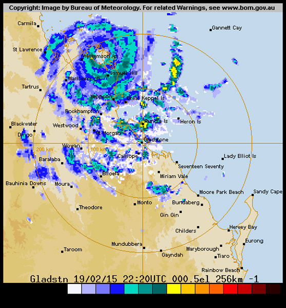
The path of the cyclone is important, we are most interested in the wind measurements that come from right under the eye.

…
Wind speed measurements came in from Middle Island (of the Percy Group) and from Samuel Hill. The distance from Rockhampton to Yeppoon is 40km by road. This radar shot of the landfall from TonyfromOz shows that the eye (headed south for Rockhampton) must have passed very close to Samuel Hill. Unmentionable kept track of measurements from Williamson, Samuel Hill, and Middle Island (of the Percy Group).
For what it’s worth TonyFromOz tells me he has never experienced winds like it, but that the leading half before the eye was much worse than the trailing half. He felt the cyclone was slowing as it passed over. So perhaps the Cat 5 was a “spike” that came and went unrecorded by anything on the ground. But will this cyclone be counted a “Cat 5” in graphs showing the trends in landfalling cyclones? Will the same modeling that finds brief spikes in cyclones be applied to past cyclones, or will the new homogenization lead to rising lines on graphs that are supposed to represent severe storms but instead represent trends in methods of cyclone observations?

…
The new rapid assessment report has been released
Thanks to Martin Clark and LittleDavey in comments for this link.
Essentially the cyclone sped up and slowed down a lot faster than anyone expected. The damage to houses was not so bad because houses are built better. But even this group share concerns that the public need to be given accurate information about wind speeds.
CTS Preliminary Damage Assessment Report
Tropical Cyclone Marcia, Queensland Australia
James Cook University / University of Florida
February 20th, 2015
On Friday, February 20, 2015 at 8:00 AM Tropical Cyclone Marcia crossed the Queensland coast North- East of Yeppoon as a Category 5 cyclone (sustained wind speeds greater than 200 km/h). The wind speeds observed in Yeppoon and Rockhampton were lower than expected. The BOM anemometers recorded maximum wind speeds of 120 km/h (10-minute mean = V600) with gusts (3-second peak = V3) up to 156 km/h at Yeppoon, and maximum wind speeds of 82 km/h (V600) with gusts up to 113 km/h (V3) at Rockhampton.
| .. | Wind Speed (km/h). |
Wind Gust (km/h). |
| Rockhampton | 82 | 113 |
| Yeppoon | 120 | 156 |
| Gladstone | 59 | 82 |
| Gladstone Airport | 48 | 72 |
| St Lawrence | 28 | 43 |
| … |
Table 2. Wind speed (V600) and gust (V3) measurements by weather station
Station
(Source: http://www.bom.gov.au/qld/observations/qldall.shtml)
SUMMARY
Wind speeds of a Category 5 cyclone are in excess of 280 km/h (V3), and between 225-279 km/h (V3) for a Category 4. Tropical Cyclone Marcia crossed the coast in a relatively unpopulated section of section. The maximum AWS wind speeds measured at population areas during the event were up to 156 km/h (V3). The design wind speed for these areas (region C cyclonic) is 69 m/s (250 km/h) (V0.2) for a 500 year return period. The winds recorded during Marcia were below the design wind speed. It is important that the wind speeds impacting the communities are determined so that: [1] assessments of building codes and standards can be made and [2] appropriate messages to the community on building performance can be articulated. A community that receives an over-represented wind speed report may have potential for complacency in preparation or building standards in the future. Further research is required to determine if this is an issue.
Despite less than design level wind speeds, significant structural damage was still observed during the cyclone event. From preliminary media images the majority of severe damage has occurred to older housing, with some cases of roof failure for retrofitted installation of new roof cladding on old roof structure. Despite wind damages, it is expected that widespread flooding (caused by the heavy rains, coastal erosion) and wind-driven rain (water ingress) are likely to be the main contributors to building/infrastructure losses in this event. The most recent report by the Queensland Police Station stated that preliminary reports indicated several hundred homes in Yeppoon and Rockhampton suffered structural damage.
Cyclone Lam in the NT also seemed to be all over very fast. It is being reported as a Cat 4.
h/t KenStewart (and his wife!) and Tonyfromoz, to Pat, Unmentionable, Martin Clark, LittleDavey and many on the Hyped thread and through emails.